Optima Lake
| Optima Lake | |
|---|---|

Optima Lake and Dam
|
|
| Location | Texas County, Oklahoma |
| Coordinates | 36°39′57.39″N 101°8′12.44″W / 36.6659417°N 101.1367889°WCoordinates: 36°39′57.39″N 101°8′12.44″W / 36.6659417°N 101.1367889°W |
| Type | reservoir |
| Basin countries | United States |
| Settlements | Hardesty, Oklahoma |
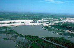
Optima Lake was built to be a reservoir in Texas County, Oklahoma. The site is located just north of Hardesty and east of Guymon in the Oklahoma Panhandle.
The earthen Optima Lake Dam (National ID # OK20510) was completed in 1978 by the United States Army Corps of Engineers, with a height of 120 feet, and a length at its crest of 16,875 feet. Although designed to contain a maximum of 618,500 acre-feet of water, the lake never reached more than 5 percent of its capacity, and remains effectively empty. Rapid declines in streamflow related to large-scale pumping from the High Plains Aquifer, also known as the Ogallala Aquifer, coincided with the completion of dam construction to make this lake a dramatic example of unanticipated environmental impacts.
The US Army Corps of Engineers website states (emphasis in original):
"Visitors should be aware that the lake's level can be very low. Depending on rainfall and evaporation rates, the lake may offer no water-based recreation and may not be suitable for swimming, fishing, boating or other activities. Visitors should come for the quiet natural setting--with or without water in the lake area."
The lake surroundings offer few to no amenities since lake camping facilities and buildings were dismantled for public safety by the Corps of Engineers in 2010.
The project was originally included as part of the Flood Control Act of 1936, as modified by the Flood Control Act of 1950, but planning and political wrangling delayed the start of construction until 1966. The intent was for the reservoir to fill primarily from the flow of the Beaver River, also known as the North Canadian River. Normal flow on the Beaver River, from 1937 to 1966, averaged 32.2 cubic feet per second. The river had occasional floods, including an October 1923 flood amounting to 109,000 acre-feet of water, and a September 1941 flood in which the Beaver’s flow increased to 44,200 cubic feet per second. The river’s most recent flow of significance was in October 1965 at 17,800 cubic feet per second. In the end the project was authorized for flood control, drinking and irrigation water in the relatively dry Oklahoma panhandle, recreation and fish & wildlife conservation.
...
Wikipedia
