Ontonagon River
| Ontonagon River | |
|---|---|

The Ontonagon River just below the confluence of its east and middle branches, as viewed from near US Highway 45
|
|
 |
|
| Basin features | |
| River mouth |
Lake Superior 46°52′35″N 89°19′40″W / 46.87633°N 89.32791°WCoordinates: 46°52′35″N 89°19′40″W / 46.87633°N 89.32791°W |
The Ontonagon River (/ˌɒntəˈnɑːɡən/ ON-tə-NAH-gən) is a river flowing to Lake Superior on the western Upper Peninsula of Michigan in the United States. The main stem of the river is 25 miles (40 km) long and is formed by a confluence of several longer branches, portions of which have been collectively designated as a National Wild and Scenic River. Several waterfalls occur on the river including Agate Falls and Bond Falls.
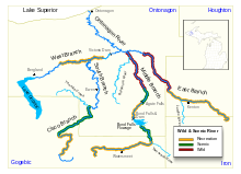
The Ontonagon River's principal tributaries are its West, South, Middle and East branches, all of which flow in part through the Ottawa National Forest:
Below the confluence of its various branches, the Ontonagon River flows generally north-northwestwardly for 24.7 miles (39.7 km) in Ontonagon County to the village of Ontonagon, where it flows into Lake Superior.
On March 3, 1992, the following reaches of the Ontonagon's upper tributaries were collectively designated the Ontonagon National Wild and Scenic River: The upper courses of the East and Middle branches in the Ottawa National Forest; the Cisco Branch in its entirety; and approximately the middle section of the West Branch, from Cascade Falls to the Victoria Reservoir.
...
Wikipedia
