Ong's Hat, New Jersey
| Ong's Hat, New Jersey | |
|---|---|
| Unincorporated community | |

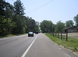
Along Magnolia Road (CR 644)
|
|
| Coordinates: 39°54′39″N 74°37′15″W / 39.91083°N 74.62083°W | |
| Country |
|
| State |
|
| County | Burlington |
| Township | Pemberton |
| Elevation | 30 m (98 ft) |
| Time zone | Eastern (EST) (UTC-5) |
| • Summer (DST) | Eastern (EDT) (UTC-4) |
| GNIS feature ID | 878993 |
Ong's Hat (also Ong) is an unincorporated community and ghost town in Pemberton Township, Burlington County, New Jersey, United States. It is located on Magnolia Road (County Route 644) west of the Four Mile Circle, where New Jersey Route 72 intersects with New Jersey Route 70. It is the northern terminus of the Batona Trail.
Although it was never more than one hut ("Ong's Hut") it still appeared on some maps as of 2006. A road in the area is named Ong's Hat Road. It is also called the Buddtown-Ong's Hat Road. It was completed in 1929, replacing an earlier dirt path.
Tha name of the place may have originally been Ong's Hut, referring to an overnight shelter built by a farmer of that name; see below.
A well-known folk story attributes the name to a local man who was a fixture at local dances, wooing women with his suave attire, especially his silk hat. The surname Ong was common among early Pine Barrens settlers, and one of the earliest settlers was named Jacob Ong. One story of the origin of the name is that at one such dance, a jealous lover stomped on his hat, ruining it, and in frustration Ong tossed it in the air, where it caught on a high branch of a pine tree. The hat remained there for many years, serving as landmark which identified the small village. At least four other versions of this legend circulate. One version simply ends with his hat being stomped on, the most widely circulated one ends with him throwing it in the tree. The other two hold that Ong was a tavern keeper who either painted a silk hat on his sign or threw his hat into a tree after getting angry with a woman.
The name of the area predates the revolutionary war. The location "Ong's" appears on a 1778 map of Hessian encampments in New Jersey. According to Forgotten Towns of Southern New Jersey by Henry Charlton Beck, Ong's Hat was a real village. According to Beck, around the 1860s, Ong's Hat was a lively town and served as a social center for the surrounding area. It was known for the availability of alcohol and one of the first arrests of a bootlegger occurred at Ong's Hat. Prizefighting was also popular.
...
Wikipedia


