Ogna (municipality)
| Ogna herad | |
|---|---|
| Former Municipality | |

|
|
| Location in Rogaland county | |
| Coordinates: 58°30′56″N 05°48′29″E / 58.51556°N 5.80806°ECoordinates: 58°30′56″N 05°48′29″E / 58.51556°N 5.80806°E | |
| Country | Norway |
| Region | Western Norway |
| County | Rogaland |
| District | Jæren |
| Municipality ID | NO-1117 |
| Adm. Center | Ogna |
| Area | |
| • Total | 104 km2 (40 sq mi) |
| Time zone | CET (UTC+01:00) |
| • Summer (DST) | CEST (UTC+02:00) |
| Created from | Eigersund in 1839 |
| Merged into | Hå in 1964 |
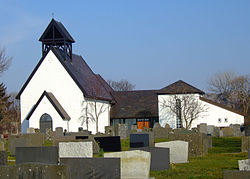
Ogna is a former municipality in Rogaland county, Norway. The 104-square-kilometre (40 sq mi) municipality existed from 1839 until its dissolution in 1964. The municipality encompassed roughly the southern third of the present-day municipality of Hå. The administrative centre of the municipality was the village of Ogna where the Ogna Church is located.
The municipality of Ogna was established in 1839 when it was split off from the (much larger) municipality of Egersund landdistrikt, the rural municipality surrounding the town of Egersund. Initially, there were 825 residents of Ogna. On 1 January 1964, there were many major municipal changes across Norway due to the work of the Schei Committee. On that date the three municipalities of Nærbø, Varhaug, and Ogna were all merged into one large municipality called Hå. Prior to the merger, Ogna municipality had 1,470 residents.
...
Wikipedia

