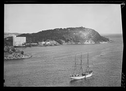
Odderøya

View of the island (c. 1948)
|
|
|
Location of the island
|
|
| Geography | |
|---|---|
| Location | Vest-Agder, Norway |
| Coordinates | 58°08′00″N 8°00′27″E / 58.1334°N 08.0075°ECoordinates: 58°08′00″N 8°00′27″E / 58.1334°N 08.0075°E |
| Area | 0.7 km2 (0.27 sq mi) |
| Length | 1.5 km (0.93 mi) |
| Width | 700 m (2,300 ft) |
| Coastline | 4 km (2.5 mi) |
| Highest elevation | 92 m (302 ft) |
| Highest point | Odderøytoppen |
| Administration | |
|
Norway
|
|
| County | Vest-Agder |
| Municipality | Kristiansand |
Odderøya is an island in Kristiansand municipality in Vest-Agder county, Norway. The 0.7-square-kilometre (170-acre) lies immediately to the south of the city centre of Kristiansand and it is connected to the mainland by four bridges. The island creates a natural division between the eastern and western parts of the port of Kristiansand. The Gravanekanalen canal separates Odderøya from the city center and Fiskebrygga (the fish market). Prior to 1993, the island was owned by the Norwegian government and it was used as a naval base and training grounds, but since that time, the municipality of Kristiansand has taken over and is now using it for recreational purposes. The island is mostly undeveloped, but the town development plan does include an area on the island for up to 500 homes.
There are signs of ancient human activity on Odderøya. At Bendiksbukta, a dagger, an ax, and other tools of flint dating back to the stone age (Around the year 1000 BC) have been found. On Odderøya, there are many interesting traces of military activity. Within this defined geographic area, there are military fortifications stretching from the Great Northern War to the end of the Cold War. Key tracks from the battle of 9 April 1940 (Operation Weserübung) are partially visible. There has been military activity on Odderøya from 1667 until 1999, when the fortress was phased out. The quarantine station or lazaretto at Odderøya was the largest in Northern Europe and was in operation from 1804 to 1914. In 1804, it was a quarantine station for all of Denmark-Norway and Holstein. The quarantine station was for ships where plague (disease) had spread aboard the ship. In connection with quarantine operations, the island also began to need its own cemetery, nicknamed the Cholera Cemetery. It is located at Kjerregårdsbukta. The quarantine station was separated from the rest of the island with a high wall that runs from the height of the hospital ("Lazaretto height") to Bendiksbukta. It was built in the years 1800 to 1807 and is under restoration.
...
Wikipedia


