Ocampo, Camarines Sur
| Ocampo | |
|---|---|
| Municipality | |
| Motto: Padagos Ocampo! | |
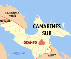
 Map of Camarines Sur showing the location of Ocampo |
|
| Location within the Philippines | |
| Coordinates: 13°34′N 123°23′E / 13.57°N 123.38°ECoordinates: 13°34′N 123°23′E / 13.57°N 123.38°E | |
| Country | Philippines |
| Region | Bicol (Region V) |
| Province | Camarines Sur |
| District | 3rd district |
| Founded | 1949 |
| Barangays | 25 |
| Government | |
| • Mayor | Corazon Olos |
| Area | |
| • Total | 118.33 km2 (45.69 sq mi) |
| Population (2015 census) | |
| • Total | 45,934 |
| • Density | 390/km2 (1,000/sq mi) |
| Time zone | PST (UTC+8) |
| ZIP code | 4419 |
| IDD : area code | +63 (0)54 |
| Income class | 3rd class; partially urban |
Ocampo is a 3rd class municipality in the province of Camarines Sur, Philippines. According to the 2015 census, it has a population of 45,934 people.
Historical documents revealed that the municipality of Ocampo, known before as Mabato-bato, was existing since 1735. Mabato-bato started as a sitio which was described as abounding with rocks and boulders of various sizes which were scattered over the place.
Since the early 1900s, the town of Ocampo had been a part of Pili though it separated years later, in 1949, and became an independent municipality.
August 13, 1949, marked a major event in the history of the town as this was the inauguration date of Ocampo's elevation into a municipality. It was also during this day when the name Matobato was officially changed into Ocampo, in honor of the late Don Julian Ocampo, then the governor of Camarines Sur.
Ocampo is the place where Governor Luis Villafuerte chose to build a sprawling deer sanctuary where at present houses different deer species from both local and foreign origins. This has served both for tourist attraction and commercial purposes.
Ocampo is politically subdivided into 25 barangays.
In the 2015 census, the population of Ocampo, Camarines Sur, was 45,934 people, with a density of 390 inhabitants per square kilometre or 1,000 inhabitants per square mile.
Partido Dialect is the primary dialect spoken in the entire town. Riŋkonāda or Rinconada Bikol is spoken by a minority of the population, along with Bicol Naga. Tagalog and English are also spoken and understood.
The religious groups in the locality are: Roman Catholic, Seventh Day Adventist, The Church of Jesus Christ of Latter Day Saints, Jehovah's Witnesses, Iglesia Ni Cristo, Word International Ministries and other groups of Born-Again Christians.
Commercial establishments include internet shops, bank, pawnshops, hardware stores, groceries, drug stores, eateries, computer shops, bakeries, motorcycle dealers, agri-dealers, gas stations and several ricemills. Various businesses are sprouting. 7 Eleven opened a branch in Barangay Poblacion Central.
Local products include palay, corn, root crops, sugarcane, coconut, and vegetables. Livestock and poultry products are also available.
...
Wikipedia

