Nyawarungu River
| Nyabarongo River | |
|---|---|

The confluence of the Nyawarungu (top right) and the Ruvuvu (top left) to form the Kagera River (foreground).
|
|

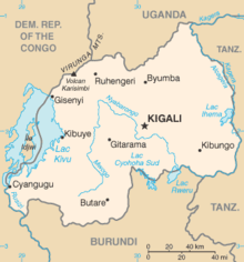
Map of Rwanda, showing location of Nyabarongo River, which flows first north, then southeast past Kigali, then east along the southeastern border of Rwanda
|
|
| Country | Rwanda, Burundi, Tanzania |
| Physical characteristics | |
| Main source | 1537 m 2°12′13″S 29°34′04″E / 2.203503°S 29.567728°E |
| River mouth | 1323 m 2°23′24″S 30°46′49″E / 2.390024°S 30.780387°ECoordinates: 2°23′24″S 30°46′49″E / 2.390024°S 30.780387°E |
| Length | 297 km |
| Basin features | |
| Tributaries |
|
The Nyabarongo (or Nyawarungu) is a major river in Rwanda, part of the upper headwaters of the Nile. At 297 km (184 miles), it is the longest river entirely in Rwanda. The river begins its course at the confluence of the rivers Mbirurume and Mwogo in the South West of the country. These two rivers themselves begin in Nyungwe Forest, and are considered by some to be the most distant source of the Nile. From its start, Nyabarongo flows northward for 85 km (53 miles), and forms the border between the Western and Southern Provinces. At the confluence with the river Mukungwa, the river changes course and flows eastward for 12 km (7.5 miles), then to a more South Eastern course for the last 200 km (124 miles). For the longest stretch of this course, the river serves as the boundary between the Northern and Southern Provinces, then between the City of Kigali and the Southern Province, and lastly between the City of Kigali and the Eastern Province. The river then before enters the Eastern Province and ends its course close to the border with Burundi. The Nyabarongo River empties both in Lake Rweru and Akagera river in a small but complicated Delta. The Akagera river outflows from Lake Rweru, a mere 1 km from the Nyabarongo delta. Almost all the branches of the Nyabarongo delta empty in the lake, however, one branch of the delta empties directly in the just formed Akagera river. The Akagera River eventually flows into Lake Victoria and forms the Nile.
The Nyabarongo River originates in southwestern Rwanda to the east of Lake Kivu. The river's sources rise in the mountain chain that covers most of the western third of Rwanda, to the east of the Albertine Rift. The main headwaters in the forested mountain country, originating at heights of 2,600 to 2,750 metres (8,530 to 9,020 ft) above sea level, are the Mbirurume and Mwogo rivers. The longest of the streams that supply the Mwogo is the Rukarara, which rises in the Nyungwe Forest. The Rukarara flows south and then east, emptying into the Mwogo River. The Mwogo flows north, merging with the Mbirurume River south of Bwakira. From this confluence, the river assumes the name Nyabarongo. The source of the Rukarara is a contender for the overall source of the Nile, the most distant headwater.
...
Wikipedia
