Nyabarongo River
| Nyabarongo River | |
|---|---|

The confluence of the Nyawarungu (top right) and the Ruvuvu (top left) to form the Kagera River (foreground).
|
|

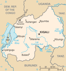
Map of Rwanda, showing location of Nyabarongo River, which flows first north, then southeast past Kigali, then east along the southeastern border of Rwanda
|
|
| Country | Rwanda, Burundi, Tanzania |
| Basin features | |
| Main source | 2°12′13″S 29°34′04″E / 2.203503°S 29.567728°E |
| River mouth | 2°23′24″S 30°46′49″E / 2.390024°S 30.780387°ECoordinates: 2°23′24″S 30°46′49″E / 2.390024°S 30.780387°E |
| Tributaries |
|
The Nyabarongo (or Nyawarungu) is a major river in Rwanda, part of the upper headwaters of the Nile. The river begins in Nyungwe Forest, at a location considered by some to be the most distant source of the Nile. From this source it follows a course up to the north-western part of the country, then down through the centre to the south-east, eventually forming the main tributary of the Kagera River, which flows into Lake Victoria.
The Nyabarongo River originates in southwestern Rwanda to the east of Lake Kivu. The river's sources rise in the mountain chain that covers most of the western third of Rwanda, to the east of the Albertine Rift. The main headwaters in the forested mountain country, originating at heights of 2,600 to 2,750 metres (8,530 to 9,020 ft) above sea level, are the Mbirurume and Mwogo rivers. The longest of the streams that supply the Mwogo is the Rukarara, which rises in the Nyungwe Forest. The Rukarara flows south and then east, emptying into the Mwogo River. The Mwogo flows north, merging with the Mbirurume River south of Bwakira. From this confluence, the river assumes the name Nyabarongo. The source of the Rukarara is a contender for the overall source of the Nile, the most distant headwater.
The Nyawarungu runs northward through the mountain chain in a deep valley roughly parallel to Lake Kivu and about the same elevation of about 1,500 metres (4,900 ft). At Muramba it swings to the southeast. On its left bank the Nyabugogo River delivers the outflow from Lake Muhazi. Around Kigali the river is used for cooking, drinking and bathing. It also receives sewage and waste from industry and agriculture. About 35 kilometres (22 mi) further downstream the Akanyaru river enters on its right bank, to the southwest of Kigali.
...
Wikipedia
