Nxai Pan National Park
| Nxai Pan National Park | |
|---|---|
|
IUCN category Ib (wilderness area)
|
|

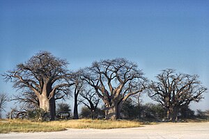
Baines Baobabs, Nxai Pan National Park, Botswana
|
|
| Location | Botswana |
| Coordinates | 20°02′30″S 24°46′08″E / 20.0416666667°S 24.7688888889°ECoordinates: 20°02′30″S 24°46′08″E / 20.0416666667°S 24.7688888889°E |
| Area | 2578 km² |
| Established | 1992 |
Nxai Pan National Park is a national park in north-eastern Botswana, consisting of Nxai Pan, which is one of the Makgadikgadi Pan salt flats. Nxai Pan National Park lies just north of the Maun-Nata main road and adjoins the Makgadikgadi Pans National Park on its northern border. The pan itself is a fossil lakebed about 40 square km in size.
The National Park is also home to the cluster of millennia-old baobab trees, which owe their name to Thomas Baines, the man known to have discovered them. Baines’ Baobabs, as they are known today, are a sight sought by many travellers venturing into this untamed terrain of Botswana.
This park is considered for inclusion in the 5 Nation Kavango - Zambezi Transfrontier Conservation Area.
...
Wikipedia
