Nui (atoll)
| Nui | |
|---|---|
| Atoll | |
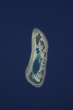
 Aerial view of Nui |
|
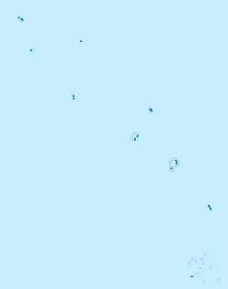
| Location in Tuvalu | |
| Coordinates: 07°13′29″S 177°09′37″E / 7.22472°S 177.16028°ECoordinates: 07°13′29″S 177°09′37″E / 7.22472°S 177.16028°E | |
| Country | Tuvalu |
| Area | |
| • Total | 3.37 km2 (1.30 sq mi) |
| Population (2012) | |
| • Total | 542 |
| • Density | 160/km2 (420/sq mi) |
| Demonym(s) | Nuian |
| ISO 3166 code | TV-NUI |
Nui is an atoll and one of nine districts of the Pacific Ocean state of Tuvalu. It has a land area of 3.37 km² and a population of 542 (2012 census).
Traditionally Nuian culture is organised in three family circles - Tekaubaonga, Tekaunimala and Tekaunibiti families. Most people live on the western end of Fenua Tapu. In the 2012 census, 321 people live in Alamoni - Maiaki and 221 people live in Manutalake - Meang (Tanrake). The junior school is Vaipuna Primary School.
Nui consists of at least 21 islets. These are:
The biggest, most southern and most eastern island is Fenua Tapu (area 1.38 km²), which is followed by Telikiai (which is the most western islet), Tokinivae, Pongalei, Talalolae, Pakantou, Unimai, Piliaieve and Motupuakaka.
The people of Nui speak the Gilbertese language, the language of Kiribati, and Tuvaluan, the official language of Tuvalu. The ancestors of Nui came from both Samoa and the Gilbert Islands in what is now Kiribati.
The island was first sighted by Europeans on 16 January 1568 by Spanish navigator Álvaro de Mendaña, who named it Isla de Jesús (Spanish for "Island of Jesus") because it was discovered on the day following the feast of the Holy Name. There are no less than six accounts of this event, that of Mendaña himself being as follows:
...
Wikipedia

