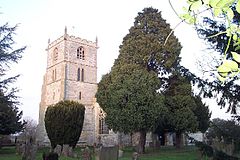
Norwell, Nottinghamshire
| Norwell | |
|---|---|
 St Laurence, Norwell |
|
| Norwell shown within Nottinghamshire | |
| Population | 490 |
| OS grid reference | SK7761 |
| District | |
| Shire county | |
| Region | |
| Country | England |
| Sovereign state | United Kingdom |
| Post town | Newark |
| Postcode district | NG23 |
| Dialling code | (+44) 1636 |
| Police | Nottinghamshire |
| Fire | Nottinghamshire |
| Ambulance | East Midlands |
| EU Parliament | East Midlands |
| UK Parliament | |
Norwell is a village and parish about 6 miles (8 km) from Newark-on-Trent, in central Nottinghamshire, England. The population (including Norwell Woodhouse) at the 2011 census was 490. It is close to the border with Lincolnshire and the River Trent, and lies approximately 1.5 miles from the A1 road and 1 mile from the East Coast Main Line.
Ordnance Survey Maps: Explorer 271 and Landranger 120. Norwell Grid Reference SK7761.
"Nortwelle" is mentioned in Domesday Book (1086); it had a church, a priest and a watermill. The parish consists of Norwell, Norwell Woodhouse, and the now deserted village of Willoughby. For nearly a thousand years the parish of Norwell was owned by the church. Rents from land and houses were used to finance three canons (or prebendaries) of Southwell. The canons were the principle landlords and lived in moated manor houses: Overhall, Palishall and Tertia Pars. In the Middle Ages some prebendaries were national figures, such as Robert de Wodehouse (died 1346) who became treasurer of England.
In other respects Norwell was a typical farming community. You can still see traces of the medieval open fields with their ridge and furrow. Major changes followed parliamentary enclosure (1832) when the land was divided into small fields. Many small farms, possibly 28, were established, some in the village centre and others in outlying fields. Today there are a few large farms and no working farms in the village centre. Some old farmyards in the village like Church, Willoughby and Hill farms have been developed for new homes.
19th century Norwell was almost self-sufficient. Blacksmiths, wheelwrights, stonemasons, and builders were often grouped together in yards leading off the main street. There were two windmills, two steam mills and a watermill. For a time Norwell had its own brickworks. Personal needs were met by General stores, bakers and butchers, shoemakers and a tailor. There were at least three public houses; The Black Horse, The Crown (later The Elephant and Castle) and The Plough. Norwell has had a school since 1727.
The medieval church of St Laurence is Grade 1 listed and has features from the 12th to the 20th century. Almost all of the buildings are of red brick with pantiles. There are many timber framed buildings originally with mud and stud between the timbers. Most are now entirel encased in brick but the timber can still be seen internally. There are a few striking 19th century houses, most of which were built by Henry Clipsham, the Norwell builder who also restored the Church. A windmill and distinctive circular pinfold can still be seen.
...
Wikipedia

