Northern Province, Zambia
| Northern | |
|---|---|
| Province | |
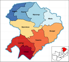
 Map of the Northern Province showing its districts. |
|
| Country |
|
| Capital | Kasama |
| Area | |
| • Total | 77,650 km2 (29,980 sq mi) |
| Population (2015) | |
| • Total | 1,304,435 |
| • Density | 17/km2 (44/sq mi) |
Northern Province is one of Zambia's ten provinces. It covers approximately one sixth of Zambia in land area. The provincial capital is Kasama. The province is made up of 8 districts, namely Kasama (the provincial capital), Chilubi, Kaputa, Luwingu, Mbala, Mporokoso, Mpulungu and Mungwi. Currently, only Kasama and Mbala have attained municipal council status, while the rest are still district councils. It is widely considered to be the heartland of the Bemba, one of the largest tribes in Zambia.
Since this article was published the new Muchinga Province has taken the Eastern districts of Northern Province and Chama district to form Zambia's tenth province.
Notable landmarks in Northern Province include Lake Tanganyika, Lake Bangweulu, and the corresponding wetlands, Lake Mweru-wa-Ntipa, and a number of waterfalls including Lumangwe Falls, Kabwelume Falls, Chishimba and Kalambo Falls.
Efforts are being made by the Zambian government, along with a number of non-governmental organizations, to increase the visibility of the many natural and historical treasures in the Northern Province. Tourism has proven an effective way to bring economic growth in other parts of Zambia, i.e. Livingstone and Victoria Falls. However, a lack of infrastructure along the vast distances between major points of interest makes visiting this part of the country difficult.
Northern Province, with a total area of 77,650 square kilometers, shares borders with two other provinces - Muchinga and Luapula, and also with two countries - the Democratic Republic of Congo in the north and Tanzania in the north-east.
...
Wikipedia
