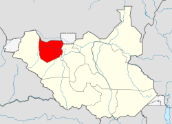
Northern Bahr el Ghazal
| Northern Bahr el Ghazal | |||||
| State | |||||
|
|||||
|
Flag |
|||||
| Location in South Sudan | |||||
| Capital | Aweil | ||||
| History | |||||
| • | Independence of South Sudan | 2011 | |||
| • | Reorganisation of states | 2015 | |||
| Area | 30,453.30 km2(11,758 sq mi) | ||||
Flag
Northern Bahr el Ghazal was one of the 10 former states of South Sudan before reorganisation in 2015. It had an area of 30,543 km² and was part of the Bahr el Ghazal region. It bordered South Darfur to the north, Western Bahr el Ghazal to the west and south, and Warrap and Abyei to the east. Aweil was the capital of the state.
Because of its proximity to Kordofan and the presence of a railway line through it to Wau it suffered extensively in the recently ended civil war in southern Sudan. North Bahr al Ghazal and adjacent parts of Western Kordofan to the north were among the most politically sensitive regions in Sudan. Missriya Arabs from Kordofan have interacted with Dinka in this region over a long time. While relations during the colonial era were largely peaceful, the recent war saw an upsurge in hostilities. Government backing to the Missriya gave them a decided advantage over local Dinka groups, and raiding by murahileen militias (and other government backed groups, including some Dinka militias) resulted in considerable loss of life, widespread abduction and pillaging of Dinka villages. Many of these raids coincided with the movement of government trains to and from Kordofan to Wau.
...
Wikipedia


