North Shields
| North Shields | |
|---|---|
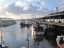
 North Shields Fish Quay |
|
| North Shields shown within Tyne and Wear | |
| Population | 49,413 (2011 census North Tyneside wards of Tynemouth, Preston, Chirton, Collingwood and part of Riverside) |
| OS grid reference | NZ3568 |
| Metropolitan borough | |
| Metropolitan county | |
| Region | |
| Country | England |
| Sovereign state | United Kingdom |
| Post town | NORTH SHIELDS |
| Postcode district | NE29, NE30 |
| Dialling code | 0191 |
| Police | Northumbria |
| Fire | Tyne and Wear |
| Ambulance | North East |
| EU Parliament | North East England |
| UK Parliament | |
North Shields is a town on the north bank of the River Tyne, in the metropolitan borough of North Tyneside, Tyne and Wear in North East England. Historically part of Northumberland, it is located eight miles (13 km) east-north east of Newcastle upon Tyne.
Its name derives from Middle English schele meaning 'temporary sheds or huts (used by fishermen)', and still today, the area is synonymous with fishing and other trades associated with seafaring.
North Shields is first recorded in 1225, when the Prior of Tynemouth, Germanus, decided to create a fishing port to provide fish for the Priory which was situated on the headland at the mouth of the River Tyne. He also supplied ships anchored near the priory. A number of rudimentary houses or 'shiels' were erected at the mouth of the Pow Burn where the stream enters the Tyne, as well as wooden quays which were used to unload the fishing boats. The quays were also used to ship coal from local collieries owned by the Priory. Soon the population of the new township numbered 1000. The burgesses of Newcastle upon Tyne were determined to preserve the custom rights that they had enjoyed up till then, which covered the whole length of the river. They successfully petitioned the king in 1290 and managed to suspend trade from the new settlement. It was forbidden to victual ships or to load and unload cargoes at North Shields. The opposition of the Newcastle burgesses remained for a considerable time but despite this, North Shields continued to develop as a centre for fishing and exporting salt, produced at local saltpans. For a considerable period the Newcastle burgesses, known as the Hostmen, who controlled the export of coal from the Tyne, resisted the export of this commodity from North Shields.
The town was originally restricted to a narrow strip of land alongside the river (around the present-day Clive Street) because of the steep bank which hemmed it in. Eventually the town became too overcrowded and in the 18th century buildings began to be erected on the plateau 60 feet (20 m) above the old, overcrowded, insanitary dwellings alongside the river. The prosperous businessmen and shipowners occupied the New Town whereas the working people remained in the lower part of town. The low, riverside part of the town was linked to the newer, higher part of the town by a series of stairs. These stairs were initially populated by slum dwellings. Although these dwellings have long since been cleared away, the sets of stairs still exist. One of the first developments of the new town was Dockwray Square, built in 1763: a set of elegant town houses that became populated by wealthy families. However, due to the poor provision of water and drainage facilities, the wealthy families soon moved to the more central part of the new town, especially the new Northumberland Square. Dockwray Square eventually deteriorated into slums. In the early twentieth century Stan Laurel lived at a house in Dockwray Square for a few years, before he became famous. The square has since been re-developed and a statue of Laurel stands in the middle to commemorate his stay there.
...
Wikipedia

