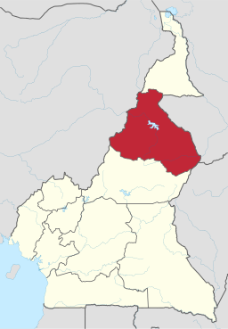
North Province, Cameroon
| North Region | |
| Region | |
| Country | Cameroon |
|---|---|
| Departments | Bénoué, Faro, Mayo-Louti, Mayo-Rey |
| Coordinates | 8°30′N 14°00′E / 8.500°N 14.000°ECoordinates: 8°30′N 14°00′E / 8.500°N 14.000°E |
| Capital | Garoua |
| Area | 66,090 km2 (25,517 sq mi) |
| Population | 2,311,179 (2013) |
| Density | 35/km2 (91/sq mi) (7th) |
| Governor | Roger-Moïse Eyène Lom |
|
Location of North Region within Cameroon
|
|
The North Region (French: Région du Nord) makes up 66,090 km² of the northern half of The Republic of Cameroon. Neighbouring territories include the Far North Region to the north, the Adamawa Region to the south, Nigeria to the west, Chad to the east, and Central African Republic to the southeast. The city of Garoua is both the political and industrial capital. Garoua is Cameroon's third largest port, despite the fact that the Bénoué River upon which it relies is only navigable for short periods of the year.
Major ethnic groups include the Fula or Fulani (Fula: Fulɓe; French: Peul), who are Islamic pastoralists, and numerous Muslim and animist speakers of Adamawa, Chadic, and Nilo-Saharan languages. French is the language of formal education, and Fulfulde, the language of the Fulbe, is widespread as a lingua franca.
In 2008, the President of the Republic of Cameroon, President Paul Biya signed decrees abolishing "Provinces" and replacing them with "Regions". Hence, all of the country's ten provinces are now known as Regions.
Bands of alternating metamorphic and sedimentary rock interspersed with granite characterise the north's geology. Granite covered in volcanic basalt makes up the southernmost reaches, which form part of the Adamawa Plateau. A series of faults lies north of this and separate the plateau from the band of metamorphic stone to its north. Random granite deposits also characterise this area. The Mayo Rey and Vina River cut north of this portion, leaving deposits of sedimentary stone except in the granite east. North of this lies a band of sedimentary alluvium, clay, limestone, and sandstone. Faults tentatively follow the Bénoué River north of this and form a barrier to split the remainder of the province, with metamorphic rocks such as gneiss, mica, and schists dominating to the south and sedimentary stone making up the north. Another large band of metamorphic rock makes up the territory northwest of the Bénoué basin. The Mandara Mountains, which run roughly north-south at the province's Nigerian border, are irregular in that they are volcanic, composed mostly of crystalline and metamorphic rock and granite.
...
Wikipedia

