North Highlands, California
| North Highlands | |
|---|---|
| Census-designated place | |
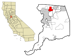
 Location in Sacramento County and the state of California |
|
| Coordinates: 38°40′23″N 121°22′22″W / 38.67306°N 121.37278°WCoordinates: 38°40′23″N 121°22′22″W / 38.67306°N 121.37278°W | |
| Country |
|
| State |
|
| County | Sacramento |
| Area | |
| • Total | 8.831 sq mi (22.873 km2) |
| • Land | 8.831 sq mi (22.873 km2) |
| • Water | 0 sq mi (0 km2) 0% |
| Elevation | 95 ft (29 m) |
| Population (2010) | |
| • Total | 42,694 |
| • Density | 4,800/sq mi (1,900/km2) |
| Time zone | Pacific (UTC-8) |
| • Summer (DST) | PDT (UTC-7) |
| ZIP code | 95660 |
| Area code | 916 |
| FIPS code | 06-51924 |
| GNIS feature IDs | 1656191, 2408941 |
North Highlands is a census-designated place (CDP) in Sacramento County, California, United States. It is part of the Sacramento–Arden-Arcade–Roseville Metropolitan Statistical Area. The population was 42,694 at the 2010 census, down from 44,187 at the 2000 census.
North Highlands is located at 38°40′23″N 121°22′22″W / 38.67306°N 121.37278°W (38.673003, -121.372698).
According to the United States Census Bureau, the CDP has a total area of 8.8 square miles (23 km2), all of it land.
According to the Köppen Climate Classification system, North Highlands has a hot-summer Mediterranean climate, abbreviated "Csa" on climate maps.
North Highlands' original school district was called the Grant Joint Union High School District but in 2008 merged with another school district, the Rio Linda Union School District, creating the Twin Rivers Unified School District. The local high school is Highlands High School, which is surrounded by quite a few elementary and charter schools. North Highlands is a low-income residential housing area with some commercial and industrial regions around the former McClellan Air Force Base, now a civilian business center and airport called McClellan Business Park. In 1995, McClellan Air Force Base was identified for closure as part of the Base Realignment and Closure (BRAC) IV process. North Highlands has a high crime rate for an area of its size, and a homicide rate four times the city itself. The main streets are Watt Avenue, Elkhorn Blvd, and Walerga road.
...
Wikipedia
