North Decatur, Georgia
| North Decatur, Georgia | |
|---|---|
| CDP | |
 Location in DeKalb County and the state of Georgia |
|
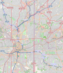
| location within central Metro Atlanta | |
| Coordinates: 33°48′11″N 84°17′24″W / 33.80306°N 84.29000°WCoordinates: 33°48′11″N 84°17′24″W / 33.80306°N 84.29000°W | |
| Country | United States |
| State | Georgia |
| County | DeKalb |
| Area | |
| • Total | 5 sq mi (12.9 km2) |
| • Land | 5 sq mi (12.9 km2) |
| • Water | 0 sq mi (0 km2) |
| Elevation | 994 ft (303 m) |
| Population (2010) | |
| • Total | 16,698 |
| • Density | 3,300/sq mi (1,300/km2) |
| Time zone | Eastern (EST) (UTC-5) |
| • Summer (DST) | EDT (UTC-4) |
| ZIP code | 30033 |
| Area code(s) | 404 770 |
| FIPS code | 13-56112 |
| GNIS feature ID | 0332514 |
North Decatur is a census-designated place (CDP) in DeKalb County, Georgia, United States. The population was 16,698 at the 2010 census.
North Decatur is located at 33°48′11″N 84°17′24″W / 33.80306°N 84.29000°W (33.803054, -84.290123).
According to the United States Census Bureau, the CDP has a total area of 5.0 square miles (12.9 km²), all of it land. The North Decatur CDP's boundaries are:
Vista Grove, which includes neighborhoods located around the intersection of LaVista Road and Oak Grove Road, is generally considered to be the community north of North Decatur. However, Vista Grove's neighborhoods that are south and southwest of LaVista Road technically lie within the North Decatur CDP.
There is no true center to North Decatur; there are three commercial clusters at corners of the CDP:
Toco Hills, a de facto commercial center for several CDPs north of the city of Decatur, has grown from a country store in 1950, with a single gas pump and a pot-bellied stove, to multiple shopping centers, coffee houses, houses of worship and townhouses.
North Decatur primarily consists of 1950's- and 1960's-era ranch homes, although condominiums are increasingly being developed in this community. Its close proximity to Atlanta's Midtown and Buckhead districts, as well as Emory University and Decatur, makes it a desirable "in-town" location for what was originally developed as a suburban community.
As of the census of 2000, there were 15,270 people, 7,974 households, and 3,333 families residing in the CDP. The population density was 3,054.0 people per square mile (1,179.2/km²). There were 8,387 housing units at an average density of 1,677.4/sq mi (647.6/km²). The racial makeup of the CDP was 83.79% White, 8.04% African American, 0.25% Native American, 5.73% Asian, 0.06% Pacific Islander, 0.65% from other races, and 1.49% from two or more races. Hispanic or Latino of any race were 2.81% of the population.
...
Wikipedia

