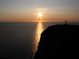
North Cape, Norway
| North Cape | |
|---|---|
| Nordkapp | |

Midnight sun at the North Cape
|
|
| Location | Finnmark, Norway |
| Coordinates | 71°10′21″N 25°47′04″E / 71.17250°N 25.78444°ECoordinates: 71°10′21″N 25°47′04″E / 71.17250°N 25.78444°E |
| Offshore water bodies | Barents Sea |
| Elevation | 307 m (1,007 ft) |
North Cape (Norwegian: Nordkapp; Northern Sami: Davvenjárga) is a cape on the northern coast of the island of Magerøya in Northern Norway. The cape is in Nordkapp Municipality in Finnmark county, Norway. The European route E69 highway has its northern terminus at North Cape, since it is a popular tourist attraction. The cape includes a 307-metre (1,007 ft) high cliff with a large flat plateau on top where visitors can stand and watch the midnight sun or the views of the Barents Sea to the north. A new visitor centre was built in 1988 on the plateau with panoramic views, a café, restaurant, post office, souvenir shop, and a so-called super video cinema.
The steep cliff of North Cape is located at 71°10′21″N 25°47′04″E / 71.17250°N 25.78444°E, about 2,102.3 kilometres (1,306.3 mi) from the North Pole. It is often referred to as the northernmost point of Europe. However, the neighbouring Knivskjellodden point, just to the west actually extends 1,457 metres (4,780 ft) further to the north. Furthermore, both of these points are situated on an island; the northernmost point of mainland Europe is located at Cape Nordkinn (Kinnarodden) which lies about 5.7 kilometres (3.5 mi) further south and about 70 kilometres (43 mi) to the east. That point is located near the village of Mehamn on the Nordkinn Peninsula. The northernmost point of Europe including islands is several hundred miles further north, either in Russia's Franz Josef Land or Norway's Svalbard archipelago, depending on whether Franz Josef Land is considered to be in Europe or in Asia.
...
Wikipedia

