Normanton, Derbyshire
| Normanton | |
|---|---|
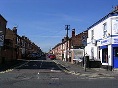
 Crewe Street, a typical Victorian terraced street in Normanton |
|
| Normanton shown within Derbyshire | |
| OS grid reference | SK345340 |
| Unitary authority | |
| Ceremonial county | |
| Region | |
| Country | England |
| Sovereign state | United Kingdom |
| Post town | DERBY |
| Postcode district | DE23 |
| Dialling code | 01332 |
| Police | Derbyshire |
| Fire | Derbyshire |
| Ambulance | East Midlands |
| EU Parliament | East Midlands |
| UK Parliament | |
Normanton is an inner city suburb and ward of the city of Derby in Derbyshire, England, situated approximately 2 miles (3.2 km) south of the city centre. Neighbouring suburbs include Littleover, Pear Tree, Rose Hill and Sunny Hill. The original village of Normanton-by-Derby, which now forms the southern part of the suburb, dates back to the medieval period. As the Normanton area became rapidly urbanised in the 19th century, the New Normanton area to the north was developed for housing, linking the old village to Derby, into which it was eventually absorbed. The area is characterised by high density late 19th century terraced housing in New Normanton and mid-20th century housing estates elsewhere, and has the most ethnically diverse population in Derby. The Normanton ward had a population of 17,071 in 2011.
The modern suburb grew from an ancient village, formerly known as Normanton-by-Derby. The area is thought to have been the site of one of the major Viking settlements in the Derby area, hence the original name, Normanestune, which means Norseman's settlement. Normanestune is mentioned twice in the Domesday Book, once recording the lands of the King and again for land belonging to Henry de Ferrers when it was valued at ten shillings.
The location of the original village lies just south of the modern ring road, its main thoroughfare commemorated by the present day Village Street. St Giles' Parish Church stands on Village Street, atop a slight hill, and its spire can be seen across most of the district. In the 1740s the Dixie family had Normanton Hall built; this was later used as a school building in the 20th century.
The portion of the district to the north of the ring road is called New Normanton. The area began to urbanise rapidly in the mid 19th century, Normanton eventually being absorbed by the expansion of Derby's boundaries up to the 1930s. Much of the housing stock in the area is typical Victorian brick terracing.
...
Wikipedia

