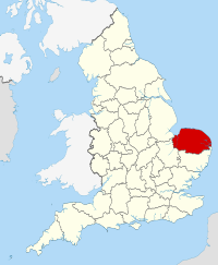
Norfolk, England
| Norfolk | |||||
|---|---|---|---|---|---|
| County | |||||
|
|||||
 Norfolk in England |
|||||
| Sovereign state | United Kingdom | ||||
| Country | England | ||||
| Region | East of England | ||||
| Established | Anglo-Saxon period | ||||
| Ceremonial county | |||||
| Lord Lieutenant | Richard Jewson | ||||
| High Sheriff | Major General Sir William Cubitt (2016-17) | ||||
| Area | 5,372 km2 (2,074 sq mi) | ||||
| • Ranked | 5th of 48 | ||||
| Population (mid-2014 est.) | 859,400 | ||||
| • Ranked | 26th of 48 | ||||
| Density | 160/km2 (410/sq mi) | ||||
| Ethnicity | 96.5% white | ||||
| Non-metropolitan county | |||||
| County council | Norfolk County Council | ||||
| Executive | Conservative | ||||
| Admin HQ | Norwich | ||||
| Area | 5,372 km2 (2,074 sq mi) | ||||
| • Ranked | of 27 | ||||
| Population | 859,400 | ||||
| • Ranked | 7th of 27 | ||||
| Density | 160/km2 (410/sq mi) | ||||
| ISO 3166-2 | GB-NFK | ||||
| ONS code | 33 | ||||
| NUTS | UKH13 | ||||
| Website | www |
||||
 Districts of Norfolk |
|||||
| Districts | |||||
| Members of Parliament | |||||
| Police | Norfolk Constabulary | ||||
| Time zone | GMT (UTC) | ||||
| • Summer (DST) | BST (UTC+1) | ||||
Norfolk /ˈnɔːrfək/ is a county in East Anglia in England. It borders Lincolnshire to the west and north-west, Cambridgeshire to the west and southwest, and Suffolk to the south. Its northern and eastern boundaries are the North Sea and, to the north-west, The Wash. The county town is Norwich.
With an area of 2,074 square miles (5,370 km2) and a population of 859,400, Norfolk is a largely rural county with a population density of 401 per square mile (155 per km²). Of the county's population, 40% live in four major built up areas: Norwich (213,000), Great Yarmouth (63,000), King's Lynn (46,000) and Thetford (25,000).
The Broads is a network of rivers and lakes in the east of the county, extending south into Suffolk. The area is a not a National Park although it is marketed as such. It has similar status to a national park, and is protected by the Broads Authority.
Norfolk was settled in pre-Roman times, with camps along the higher land in the west, where flints could be quarried. A Brythonic tribe, the Iceni, inhabited the county from the 1st century BC to the end of the 1st century AD. The Iceni revolted against the Roman invasion in AD 47, and again in 60 led by Boudica. The crushing of the second rebellion opened the county to the Romans. During the Roman era roads and ports were constructed throughout the county and farming was widespread.
...
Wikipedia


