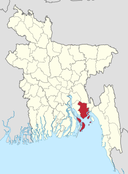
Noakhali District
|
Noakhali নোয়াখালী জিলা |
|
|---|---|
| District | |
| Nickname(s): নোয়াখালী | |
 Location of Noakhali in Bangladesh |
|
| Coordinates: 22°42′N 91°06′E / 22.70°N 91.10°ECoordinates: 22°42′N 91°06′E / 22.70°N 91.10°E | |
| Country |
|
| Division | Chittagong Division |
| Area | |
| • Total | 4,202.70 km2 (1,622.67 sq mi) |
| Population (2011 census) | |
| • Total | 3,108,083 |
| • Density | 740/km2 (1,900/sq mi) |
| Literacy rate | |
| • Total | 51.3% |
| Time zone | BST (UTC+6) |
| Postal code | 3800 |
| Website | www.noakhali.gov.bd |
Noakhali (Bengali: নোয়াখালী জিলা) is a district in South-eastern Bangladesh. It is located in the Chittagong Division. Noakhali district, whose earlier name was Bhulua, was established in 1821. It was named Noakhali in 1868.
Noakhali District is bordered by Comilla district to the north, the Meghna estuary and the Bay of Bengal to the south, Feni and Chittagong districts to the east and Lakshmipur and Bhola district to the west. The district has an area of 4202 km2. The district represents an extensive flat, coastal and delta land, located on the tidal floodplain of the Meghna River delta, characterised by flat land and low relief. The area is influenced by diurnal tidal cycles and the tidal fluctuations vary depending on seasons, being pronounced during the monsoon season. Around Noakhali on three sides is an alluvial plain that is annually inundated and fertilised by silt deposits from the Meghna estuary. The swift currents that course down from the Himalayas bring a rich bath of fertile silt, when it reaches the Bay of Bengal, settles along the coast, gradually forming new land called "chars". The district of Noakhali has actually gained more than 28 square miles (73 km2) of land in the past 50 years and so on.
Noakhali has tropical climate and it has significant rainfall most months, with a short dry season. In Noakhali, the average annual temperature is 25.6 °C and the average annual rain fall is about 3302 mm. With an average of 33.6 °C, May is the warmest month. At 19.5 °C on average, January is the coldest month of the year. The driest month is January with 8 mm of precipitation. In July, the rainfall reaches its peak, with an average of 671 mm.
The ancient name of Noakhali is Bhulua. In the 1660s, the agricultural activities of the north-eastern region of Bhulua were seriously affected by floodwater of the Dakatia River following from the Tripura hills. To salvage the situation, a canal was dug in 1660 that ran from the Dakatia through Ramganj, Sonaimuri and Chaumuhani to divert water flow to the junction of the river Meghna and Feni. After excavating this long canal, Bhulua began to be known as "Noakhali". The name "Noakhali" was originated from the term Noa (New) and Khal (Canal).
...
Wikipedia
