Ngatik

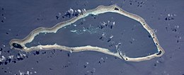
NASA picture of Sapwuahfik Atoll
|
|
| Geography | |
|---|---|
| Location | Pacific Ocean |
| Coordinates | 5°47′16″N 157°09′12″E / 5.7878°N 157.1533113°E |
| Total islands | 10 |
| Major islands | Ngatik |
| Length | 22.5 km (13.98 mi) |
| Width | 9.6 km (5.97 mi) |
| Administration | |
|
Federated States of Micronesia
|
|
| State | Pohnpei |
| Area covered | 110 km2 (42 sq mi) |
| Demographics | |
| Population | 433 (2010) |
| Languages | |
| Additional information | |
| Time zone |
|
Sapwuahfik, formerly Ngatik, or the Raven Islands is a 110-square-kilometre (42 sq mi) atoll of the Federated States of Micronesia. It is a village and municipality of roughly 430 people on a land area of 1.5 square kilometres (0.58 sq mi) in the state of Pohnpei.
It is located 150 km (93 mi) southwest of the main island of Pohnpei in the Eastern Caroline Islands and consists of 10 individual islands on the reef. The largest and only inhabited island is Ngatik, at the western end.
The atoll is 22.5 km (14.0 mi) long and up to 9.6 km (6.0 mi) wide. The lagoon measures 78.56 km2 (30.33 sq mi) in area, and the total area is 114 km2 (44 sq mi). The aggregate land area of the 10 islands is 1.75 km2 (0.68 sq mi), of which the main island Ngatik is 0.91 km2 (0.35 sq mi), or more than half. While Ngatik is the only inhabited island, the six larger of the remaining islands are used by the population for harvesting coconuts and growing taro, and animal husbandry (pigs and chickens). There are 12 buildings for temporary shelter on those islands.
The islands, clockwise, starting at Ngatik in the west:
Sapwuahfik has an airstrip that lies just off the island of Ngatik, the Sapwuahfik Civil Airfield (5°47′01″N 157°10′02″E / 5.783711°N 157.167276°E). Coastal erosion has cut the airstrip off from the island by about 20 meters, making it necessary to ferry arriving and departing passengers between it and Ngatik by boat. There are on-call personnel who go to the airfield whenever a flight is expected.
...
Wikipedia


