Ngaliema
|
Ngaliema Commune de Ngaliema |
|
|---|---|
| Commune | |
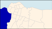
 Ngaliema on a map of Kinshasa communes |
|
 Kinshasa city-province on a map of the DRC |
|
| Coordinates: 04°20′56″S 15°15′10″E / 4.34889°S 15.25278°ECoordinates: 04°20′56″S 15°15′10″E / 4.34889°S 15.25278°E | |
| Country | Democratic Republic of the Congo |
| Province | Kinshasa |
| District | Lukunga |
| Area | |
| • Total | 224.3 km2 (86.6 sq mi) |
| Population (2004 est.) | |
| • Total | 683,135 |
| • Density | 3,000/km2 (7,900/sq mi) |
Ngaliema is a municipality (commune) in the Lukunga District of Kinshasa, the capital city of the Democratic Republic of the Congo.
Ngaliema is situated in the west of Kinshasa. It stretches south towards Mont Ngaliema and along the main road linking Kinshasa and the city of Matadi in Bas-Congo. The boundary between Ngaliema and the Mont Ngafula commune is defined by the Lukunga River.
In addition to the communities of Binza Ozone, Binza Météo, Binza Delvaux and Binza I.P.N., the area also accommodates:
...
Wikipedia
