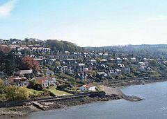
Newport on Tay
Newport-on-Tay
|
|
|---|---|
 |
|
| Newport-on-Tay shown within Fife | |
| Population | 7,922 |
| OS grid reference | NO421279 |
| Council area | |
| Lieutenancy area | |
| Country | Scotland |
| Sovereign state | United Kingdom |
| Post town | NEWPORT-ON-TAY |
| Postcode district | DD6 |
| Dialling code | 01382 |
| Police | Scottish |
| Fire | Scottish |
| Ambulance | Scottish |
| EU Parliament | Scotland |
| UK Parliament | |
| Scottish Parliament | |
Newport-on-Tay is a small town in the north-east of Fife in Scotland, acting as a commuter suburb for Dundee. The Fife Coastal Path passes through Newport-on-Tay. The area itself is surrounded by views of the two bridges that cross the River Tay and distant views of the Scottish Highlands.
The town was established near the endpoint of one part of a ferry route that itself was started in the 12th century.
In 1715 a new pier and inn were built, the work being funded by the Guilds of Dundee which resulted in the settlement being called "New Dundee". Thomas Telford built a new harbour in the 1820s, and the town expanded and grew into a commuter suburb of Dundee as the prosperous jute manufacturers, industrialists and the middle and upper working class of Dundee established fashionable residences in Newport.
The local war memorial dates from 1920 and was designed by Sir Robert Lorimer.
Newport-on-Tay formerly had two railway stations - the East and West stations on what was the Newport Railway. Both stations (and the Tayport-Dundee branch line) closed in 1969, having lost much of their business following the opening of the Tay Road Bridge in 1966. In fact, trains had ceased to run beyond Newport-on-Tay East station to Tayport on 22 May 1966 so that the railway line could be breached to build the bridge's southern approach road. The Dundee - Newport ferry also closed promptly later in 1966 on the opening of the Tay Road Bridge. However, the ferry terminal buildings and slipways still survive at the foot of Boat Hill as a boat repair yard.
...
Wikipedia

