Newland, North Carolina
| Newland, North Carolina | |
|---|---|
| Town | |

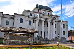
Avery County Courthouse
|
|
 Location of Newland, North Carolina |
|
| Coordinates: 36°5′11″N 81°55′36″W / 36.08639°N 81.92667°WCoordinates: 36°5′11″N 81°55′36″W / 36.08639°N 81.92667°W | |
| Country | United States |
| State | North Carolina |
| County | Avery |
| Incorporated | 1911 |
| Government | |
| • Type | Mayor-council |
| • Mayor | Valerie Jaynes |
| Area | |
| • Total | 0.7 sq mi (1.7 km2) |
| • Land | 0.7 sq mi (1.7 km2) |
| • Water | 0.0 sq mi (0.0 km2) |
| Elevation | 3,606 ft (1,099 m) |
| Population (2010) | |
| • Total | 698 |
| • Density | 997.1/sq mi (410.5/km2) |
| Time zone | Eastern (EST) (UTC-5) |
| • Summer (DST) | EDT (UTC-4) |
| ZIP code | 28657 |
| Area code(s) | 828 |
| FIPS code | 37-46740 |
| GNIS feature ID | 1013943 |
| Website | Newland, North Carolina |
Newland is a town in Avery County, North Carolina, United States. The population was 698 at the 2010 census. It is the county seat of Avery County.
Before its founding, the area was known as Old Fields or Old Fields of Toe. In 1911 it was renamed Newland, after North Carolina Lieutenant Governor William C. Newland, and simultaneously became the county seat for Avery County.
The Avery County Courthouse and Avery County Jail are listed on the National Register of Historic Places.
Newland is located at 36°5′11″N 81°55′36″W / 36.08639°N 81.92667°W (36.086509, -81.926664).
According to the United States Census Bureau, the town has a total area of 0.7 square miles (1.8 km2), all land.
At an elevation of 3,621 feet or 1,104 metres, it is the highest county seat in the Eastern United States (based on elevations in the USGS database).
The East Tennessee and Western North Carolina Railroad ("Tweetsie") passed through the town until 1940.
As of the census of 2000, there were 704 people, 334 households, and 207 families residing in the town. The population density was 1,044.4 people per square mile (405.7/km²). There were 363 housing units at an average density of 538.5 per square mile (209.2/km²). The racial makeup of the town was 99.01% White, 0.99% from other races. Hispanic or Latino of any race were 1.56% of the population.
...
Wikipedia
