Newkirk, Oklahoma
| Newkirk, Oklahoma | |
|---|---|
| City | |

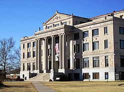
Kay County Courthouse (2010)
|
|
 Location of Newkirk within Oklahoma |
|
| Coordinates: 36°52′59″N 97°3′21″W / 36.88306°N 97.05583°WCoordinates: 36°52′59″N 97°3′21″W / 36.88306°N 97.05583°W | |
| Country | United States |
| State | Oklahoma |
| County | Kay |
| Government | |
| • Type | Council-manager |
| Area | |
| • Total | 1.3 sq mi (3.4 km2) |
| • Land | 1.3 sq mi (3.4 km2) |
| • Water | 0.0 sq mi (0.0 km2) |
| Elevation | 1,152 ft (351 m) |
| Population (2010) | |
| • Total | 2,317 |
| • Density | 1,800/sq mi (680/km2) |
| Time zone | Central (CST) (UTC-6) |
| • Summer (DST) | CDT (UTC-5) |
| ZIP code | 74647 |
| Area code(s) | 580 |
| FIPS code | 40-51300 |
| GNIS feature ID | 1095856 |
| Website | Newkirk CoC |
Newkirk is a city and county seat of Kay County, Oklahoma, United States. The population was 2,317 at the 2010 census.
Newkirk is located on land known as the Cherokee Strip which belonged to the Cherokee Indians. In 1893, the Cherokee sold the land, then part of Oklahoma Territory to the United States government. The land was opened to White settlement by means of the Cherokee Strip Land Run on September 16, 1893. More than 100,000 people raced to claim plots of land.
The town of Newkirk had been laid out before the run by the government as the county seat of “K” county. It was named Lamoreaux after Silas W. Lamoreaux, who was commissioner of the General Land Office. Two miles north of Lamoreaux was Kirk, a Santa Fe Railroad cattle-shipping station.
That first day of the land run, 5,000 people staked claims in and near Lamoreaux. Claimants were allowed two town lots: one for a home and one for a business. In designated rural areas, claimants could select 160 acres. The population quickly dropped to about 2,100 as disappointed land seekers left. A town government was organized and among the first items of business was to change the name of the town from Lamoreaux to Santa Fe. The railroad, however, did not approve the name as several other places were named Santa Fe. Meanwhile, the railroad station at Kirk had been closed, so the name Newkirk was chosen on November 8, 1893.
In 1901, Newkirk suffered a major reversal when nearly a whole block of its thriving downtown burned. The wood buildings that burned were mostly replaced with stone buildings from the distinctive yellow limestone quarried four miles east of Newkirk. “Imposing stone buildings began to give dignity and permanence to the dusty streets, while wood-frame homes gradually replaced the “proving-up” homes of the Run. Young Elms, Cottonwoods, shrubs, and flowers began to change the once treeless prairies into shaded garden spots.” Newkirk’s business district was placed on the National Register as a historic district in 1984.
After Oklahoma became a state in 1907, Newkirk, Blackwell, and Ponca City vied to become the county seat. An election on September 3, 1908, gave Blackwell 2,038 votes, Newkirk 2,063, and Ponca City 1,388. Governor Haskell declared Newkirk as the winner. Blackwell sued, but lost, and Newkirk retained the title. The present Kay County courthouse was built in 1926, replacing the original 1894 wooden structure which had burned.
...
Wikipedia
