New York State Route 385
| New York State Route 385 | ||||
|---|---|---|---|---|

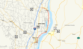
Map of Greene County in eastern New York with NY 385 highlighted in red
|
||||
| Route information | ||||
| Maintained by NYSDOT | ||||
| Length: | 13.79 mi (22.19 km) | |||
| Existed: | c. 1932 – present | |||
| Major junctions | ||||
| South end: |
|
|||
| North end: |
|
|||
| Location | ||||
| Counties: | Greene | |||
| Highway system | ||||
|
||||
New York State Route 385 (NY 385) is a state highway in Greene County, New York, in the United States. It runs from the village of Catskill to the village of Coxsackie, serving as an alternate route of U.S. Route 9W between the two locations. While US 9W follows a more inland routing, NY 385 runs along the Hudson River and serves the village of Athens. Modern NY 385 is the original routing of US 9W between Catskill and Coxsackie. NY 385 was originally assigned c. 1932 to what is now US 9W between Catskill and Coxsackie; however, the alignments of both routes were flipped by the following year.
NY 385 begins at a fork from US 9W (West Bridge Street / Maple Avenue) in the village of Catskill. Proceeding northeast along West Bridge Street, NY 385 is a two-lane mixed residential/commercial street through the southern end of the village, becoming a commercial street just before crossing over Catskill Creek. After Catskill Creek, the route enters downtown Catskill, crossing northeast into another residential neighborhood, where it junctions with Spring Street. At Spring Street, NY 385 turns north while Bridge Street dead-ends two blocks away. NY 385 along Spring Street is primarily residential, passing several blocks of homes through Catskill, soon reaching a junction with NY 23 and access to the Rip Van Winkle Bridge, which crosses the Hudson River.
...
Wikipedia

