New York State Route 233
| New York State Route 233 | ||||
|---|---|---|---|---|

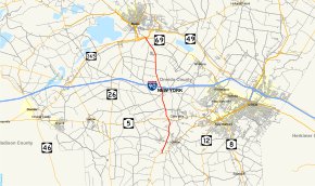
Map of Oneida County in central New York with NY 233 highlighted in red
|
||||
| Route information | ||||
| Maintained by NYSDOT | ||||
| Length: | 12.04 mi (19.38 km) | |||
| Existed: | 1930 – present | |||
| Major junctions | ||||
| South end: |
|
|||
|
|
||||
| North end: |
|
|||
| Location | ||||
| Counties: | Oneida | |||
| Highway system | ||||
|
||||
New York State Route 233 (NY 233) is a state highway in Oneida County, New York, United States. The southern terminus of the route is at an intersection with NY 12B southwest of the Clinton. Its northern terminus is at an interchange with the Utica–Rome Expressway within the Rome city limits but southeast of the inner tax boundary. NY 233 is the most direct connection between Rome and the New York State Thruway, which it meets at exit 32 in Westmoreland.
NY 233 begins at an intersection with NY 12B southwest of the village of Clinton in the town of Kirkland. It heads north as Harding Road and passes the Harding Farm historic site before intersecting NY 412 (College Hill Road) directly west of Clinton. NY 412 heads east from here to serve Clinton while College Hill Road heads west to serve Hamilton College. North of the NY 412 junction, NY 233 is named Bristol Road as it passes through the hamlet of Kirkland (where it meets NY 5) and enters the town of Westmoreland.
...
Wikipedia

