New York State Route 100C
| New York State Route 100C | ||||
|---|---|---|---|---|

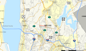
Map of Westchester County in southeastern New York with NY 100C highlighted in red
|
||||
| Route information | ||||
| Auxiliary route of NY 100 | ||||
| Maintained by NYSDOT | ||||
| Length: | 1.24 mi (2.00 km) | |||
| Existed: | late 1930s – present | |||
| Major junctions | ||||
| West end: |
|
|||
|
|
||||
| East end: |
|
|||
| Location | ||||
| Counties: | Westchester | |||
| Highway system | ||||
|
||||
New York State Route 100C (NY 100C) is an east–west spur route of NY 100 located in Westchester County, New York, in the United States. It extends for 1.24 miles (2.00 km) as Grasslands Road along the Greenburgh–Mount Pleasant town line from an intersection with NY 9A (Saw Mill River Road) to a junction with NY 100 and NY 100A. NY 100C has a junction with the Sprain Brook Parkway near its eastern terminus. The eastern terminus of NY 100C also serves as NY 100A's northern endpoint.
NY 100C begins at an interchange with NY 9A (Saw Mill River Road) in the town of Greenburgh. The route heads eastward as Grasslands Road, a continuation of County Route 303 (CR 303, an unsigned route) which heads towards the hamlet of Eastview. Just east of the interchange, NY 100C crosses through a commercial park, entering the town of Mount Pleasant for a short distance before paralleling the Greenburgh town line. Along this line, NY 100C enters a grade-separated interchange with the Sprain Brook Parkway. A short distance from the interchange, NY 100C intersects with NY 100 (Bradhurst Avenue) and NY 100A (Knollwood Road). This intersection serves as the eastern terminus of NY 100C, as Grasslands Roads continues east as NY 100.
...
Wikipedia

