New Llano, Louisiana
| New Llano, Louisiana | |
| Town | |
| Country | United States |
|---|---|
| State | Louisiana |
| Parish | Vernon |
| Elevation | 217 ft (66.1 m) |
| Coordinates | 31°06′53″N 93°16′47″W / 31.11472°N 93.27972°WCoordinates: 31°06′53″N 93°16′47″W / 31.11472°N 93.27972°W |
| Area | 1.0 sq mi (2.6 km2) |
| - land | 1.0 sq mi (3 km2) |
| - water | 0.0 sq mi (0 km2), 0% |
| Population | 2,415 (2000) |
| Density | 2,488.0/sq mi (960.6/km2) |
| Timezone | CST (UTC-6) |
| - summer (DST) | CDT (UTC-5) |
| Area code | 337 |
|
Location in Vernon Parish and the state of Louisiana.
|
|
|
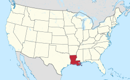
Location of Louisiana in the United States
|
|
New Llano is a town in Vernon Parish, Louisiana, United States. The population was 2,415 at the 2000 census. It is part of the Fort Polk South Micropolitan Statistical Area.
Originally Stables, Louisiana, the town was renamed when 200 members of the Socialist commune Llano del Rio Cooperative Colony in California relocated to this site in 1917, giving the town its present name. It continued to function as a socialist commune with citizens pooling and sharing resources and wealth until 1939.
New Llano is located at 31°6′53″N 93°16′47″W / 31.11472°N 93.27972°W (31.114793, -93.279793).
According to the United States Census Bureau, the town has a total area of 1.0 square mile (2.5 km²), all land.
As of the census of 2000, there were 2,415 people, 925 households, and 640 families residing in the town. The population density was 2,488.0 people per square mile (961.3/km²). There were 1,037 housing units at an average density of 1,068.3 per square mile (412.8/km²). The racial makeup of the town was 46.09% White, 40.29% African American, 0.83% Native American, 3.77% Asian, 0.29% Pacific Islander, 4.10% from other races, and 4.64% from two or more races. Hispanic or Latino of any race were 8.57% of the population.
...
Wikipedia


