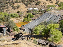
New Idria, California
|
New Idria Idria |
|
|---|---|
| Ghost town | |

New Idria grounds, 2004
|
|
| Location within the state of California | |
| Coordinates: 36°25′1″N 120°40′28″W / 36.41694°N 120.67444°WCoordinates: 36°25′1″N 120°40′28″W / 36.41694°N 120.67444°W | |
| Country | United States |
| State | California |
| County | San Benito County |
| Elevation | 2,648 ft (807 m) |
| Time zone | Pacific (UTC−8) |
| • Summer (DST) | PDT (UTC−7) |
| Area code | 831 |
| FIPS code | 06-36182 |
| GNIS feature ID | 1660786 |
| Official name | New Idria Mine |
| Reference no. | 324 |
New Idria was an unincorporated town in San Benito County, California. It was named after the New Idria Mercury Mine, which closed in 1972, resulting in a ghost town.
The area is inside Area code 831. It is included in the Monterey Bay Unified Air Pollution Control District and the Panoche Elementary School District.San Benito Mountain, elevation 5,241 feet (1,597 m), is located 3.6 miles (5.8 km) southeast. The nearest city is King City along U.S. Route 101.
The New Idria Mercury Mine was named in honor of the world's then second largest quicksilver mine in what was then Idria, Austria, now Idrija, Slovenia; (Slovene pronunciation [ĭdrija], California English pronunciation [īdria].) The town grew to support the mining operations, but the mine closed in the 1970s. The town is currently an abandoned ghost town with more than 100 standing buildings, though vandalism has contributed to their deterioration in recent years. According to the US Geological Survey, both Idria (primary) and New Idria (variant) are recognized for federal use in describing the community.
The community was established to support the mine, which mainly extracted mercury, since cinnabar was abundant in the local rock formations. Mercury mining at the location began in 1854. At one time, the New Idria mines were America's second most productive mines, with the New Almaden mines in the vicinity of San Jose, about 82 miles (132 km) northwest, being the first.
...
Wikipedia

