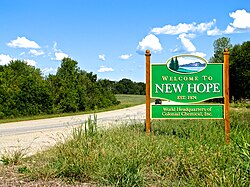
New Hope, Tennessee
| New Hope, Tennessee | |
|---|---|
| City | |
 |
|
 Location of New Hope, Tennessee |
|
| Coordinates: 35°0′0″N 85°39′12″W / 35.00000°N 85.65333°WCoordinates: 35°0′0″N 85°39′12″W / 35.00000°N 85.65333°W | |
| Country | United States |
| State | Tennessee |
| County | Marion |
| Area | |
| • Total | 10.4 sq mi (26.9 km2) |
| • Land | 10.3 sq mi (26.7 km2) |
| • Water | 0.1 sq mi (0.1 km2) |
| Elevation | 715 ft (218 m) |
| Population (2012) | |
| • Total | 1,077 |
| • Density | 101.1/sq mi (39.0/km2) |
| Time zone | Central (CST) (UTC-6) |
| • Summer (DST) | CDT (UTC-5) |
| FIPS code | 47-52780 |
| GNIS feature ID | 1310070 |
New Hope is a city in Marion County, Tennessee, United States. The population was 1,082 at the 2010 census, up from 1,043 in 2000. It is part of the Chattanooga, TN–GA Metropolitan Statistical Area.
Originally known as Antioch, New Hope incorporated in 1974 to avoid an annexation attempt by South Pittsburg, which most of the new city's residents opposed. The name "New Hope" was taken from a local church and cemetery.
New Hope is located at 35°0′0″N 85°39′12″W / 35.00000°N 85.65333°W (35.000112, -85.653332). The city occupies the south side of a U-shaped bend of the Tennessee River, mostly downstream from Nickajack Dam. The city's municipal boundary stretches southward to the Tennessee-Alabama state line. South Pittsburg lies across the river to the west, Kimball and Jasper lie across the river to the north, and Nickajack Lake lies to the east. State Route 156 spans New Hope from east-to-west, connecting the city with U.S. Route 72 in South Pittsburg and Interstate 24 near Haletown.
...
Wikipedia
