New Addington
| New Addington | |
|---|---|
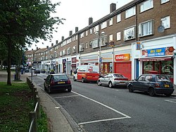
 Central Parade |
|
| New Addington shown within Greater London | |
| Population | 10,801 (2011 Census. Ward) |
| OS grid reference | TQ382622 |
| • Charing Cross | 12 mi (19 km) NNW |
| London borough | |
| Ceremonial county | Greater London |
| Region | |
| Country | England |
| Sovereign state | United Kingdom |
| Post town | CROYDON |
| Postcode district | CR0 |
| Dialling code |
020 01689 |
| Police | Metropolitan |
| Fire | London |
| Ambulance | London |
| EU Parliament | London |
| UK Parliament | |
| London Assembly | |
New Addington is an area in South London, England in the London Borough of Croydon. It is located south of Addington near the Greater London border with Surrey. It is a large local authority estate surrounded by the Metropolitan Green Belt of open countryside, woodland and golf courses. The Prime Meridian crosses the eastern edge of New Addington.
The area's isolation from the rest of the Croydon borough has given it a strong sense of community and independence. The Croydon Advertiser publishes a separate New Addington edition. The presence of the library, youth clubs, leisure centre, shops, churches and street market enables locals to lead full lives in many ways. The Addington Community Association has provided an important hub for the community. It has been notable for its local gangs.
Until the 1930s, the area now known as New Addington was farmland and woodland in the southeast of the ancient parish of Addington. The farms were called Castle Hill, Addington Lodge and Fisher's Farms. At the time, central Croydon and London more generally had overcrowded slums causing concern to the authorities. In 1935, the First National Housing Trust purchased 569 acres (2.3 km²) of Fisher's Farm with the intention of erecting a 'Garden Village', with 4,400 houses, shops, two churches, cinema, and village green. The Chairman of the Trust was Charles Boot, hence the earliest part of New Addington is sometimes called The Boot's Estate.
By 1939, when the outbreak of World War II suspended construction, 1,023 houses and 23 shops had been built. The new estate was popular, but the provision of amenities had not kept pace with the house building. Only one of the proposed schools and few of the shops were in operation. For employment, decent shopping and entertainment, the residents had to travel off the estate. This heralded a long history of isolation for the estate, then nicknamed Little Siberia, because it is much colder than the rest of Croydon. The isolation was partly remedied 60 years later with the arrival of Tramlink route 3, mentioned below. Tramlink runs alongside Lodge Lane, the main (northern) road access. There is only one other point of access by road, where King Henry's Drive connects with minor roads to the south.
...
Wikipedia

