Netherne-on-the-Hill
| Netherne-on-the-Hill | |
|---|---|
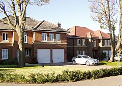
 Homes added in the first decade of the 21st century |
|
 Apartments occupying a former water tower serving Hooley and the hospital |
|
| Netherne-on-the-Hill shown within Surrey | |
| Population | 1,400 (approximately half of Hooley and Netherne-on-the-Hill) |
| OS grid reference | TQ297564 |
| District | |
| Shire county | |
| Region | |
| Country | England |
| Sovereign state | United Kingdom |
| Post town | Coulsdon |
| Postcode district | CR5 |
| Dialling code | 01737 |
| Police | Surrey |
| Fire | Surrey |
| Ambulance | South East Coast |
| EU Parliament | South East England |
| UK Parliament | |
Netherne-on-the-Hill is a village in Surrey, England, occupying a plateau once home to Netherne Hospital. The village is across a narrow valley from Hooley in north of the borough of Reigate and Banstead; through the valley runs the Hooley Tunnel cutting and A23, the only road from which the village can be accessed, from two designated side roads; a few metres south of the southern T-junction, the road divides into two grades: the A23 to Redhill, 3 miles (4.8 km) south, and the M23 motorway which has a junction with the M25 motorway within Merstham's boundaries, the former village of the hilltop land. The post town, Coulsdon in Greater London is centred 1.8 miles (2.9 km) due north.
Unlike Hooley which was mostly part of Coulsdon manor and parish, the land here was within the traditional boundaries of Merstham as a village, that is within its ecclesiastical parish. The property called Netherne — 'Lez Nedder' in 1522 — was acquired in the first decade of the 20th century by the Surrey County Council for an asylum; the quit-rent payable yearly for the land of a little over half of one pound sterling recorded in 1522 was enfranchised from the land by the Council paying its owner.
Being on the ridge of the North Downs, the relevant mineral prosperity of the parish was important at the slopes straddling this particular plateau, very sparsely inhabited though it was, and increasingly bereft of water, being aloft of aquifers. The county history of 1911 states:
...
Wikipedia

