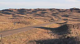
Nebraska Sandhills
| Sandhills | |
| Region | |
|
Sandhills in Hooker County, near sunset in October
|
|
| Country | |
|---|---|
| State | |
| Part of | Great Plains, High Plains |
| Rivers | Niobrara River, Snake River, North Loup River, Middle Loup River, Dismal River |
| Area | 19,600 sq mi (50,764 km2) |
|
The Sandhills covers portions of northern and western Nebraska.
|
|
| Designated | 1984 |
The Sandhills, often written Sand Hills, is a region of mixed-grass prairie on grass-stabilized sand dunes in north-central Nebraska, covering just over one quarter of the state. The dunes were designated a National Natural Landmark in 1984.
The sandhills are found in Arthur, Blaine, Brown, Cherry, Custer, Garden, Garfield, Grant, Holt, Hooker, Lincoln, Keith, Logan, Loup, McPherson, Morrill, Rock, Sheridan, Thomas, and Wheeler counties.
The boundaries of the Sandhills are variously defined by different organizations. Depending on the definition, the region's area can be as small as 19,600 mi2 (50,760 km2) or as large as 23,600 mi2 (61,100 km2).
Dunes in the Sandhills may exceed 330 ft (100 m) in height. The average elevation of the region gradually increases from about 1,800 ft (550 m) in the east to about 3,600 ft (1,100 m) in the west.
...
Wikipedia


