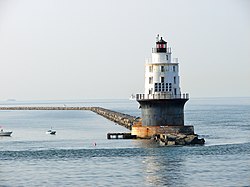
National Harbor of Refuge and Delaware Breakwater Harbor Historic District
|
National Harbor of Refuge and Delaware Breakwater Harbor Historic District
|
|
 |
|
| Location | Mouth of Delaware Bay at Cape Henlopen, Lewes, Delaware |
|---|---|
| Coordinates | 38°47′59″N 75°6′27″W / 38.79972°N 75.10750°WCoordinates: 38°47′59″N 75°6′27″W / 38.79972°N 75.10750°W |
| Architect | Strickland, William |
| NRHP Reference # | 89000289 |
| Added to NRHP | March 27, 1989 |
The National Harbor of Refuge and Delaware Breakwater Historic District encompasses a series of seacoast breakwaters behind Cape Henlopen, Delaware that were built in a program to establish a shipping haven on a coastline that lacked safe harbors. The Harbor of Refuge is at the mouth of the Delaware Bay estuary where it opens into the Atlantic Ocean, at Lewes. The district is almost entirely offshore, only touching land at the former United States Coast Guard station. It was added to the National Register of Historic Places in 1989.
An 1822 study authorized by the United States Congress investigated the possibility of a haven at Cape Henlopen, led by General Simon Bernard, Major Joseph Gilbert Totten and Commodore William Bainbridge. The committee recommended that a permanent harbor be created.
The project began in 1826, designed by William Strickland. The harbor was the first of its kind in the Western hemisphere and the third in the world, after Cherbourg, France and the Plymouth Breakwater at Plymouth, England. Work began in 1828 on what is now the inner breakwater, listed in its own right on the National Register as the Delaware Breakwater. These works consisted of a 2,100-foot (640 m) main breakwater and an ice breaker pier 1,700 feet (520 m) long. Both elements were built of granite rubble from New Castle County, Delaware, with earlier portions using smaller stones from the Hudson Palisades. The breakwaters are 160 feet (49 m) wide at the base and 20 feet (6.1 m) at the top. The project used 835,000 tons of stone in all. Strickland designed a lighthouse for the harbor, which was completed the next year. The harbor was a success, but it soon became apparent that it was too small. During storms as many as 200 ships would seek refuge. Shoaling was also a problem. In 1877 a hurricane destroyed several ships in the harbor, and others that could not get into the harbor. Seventy sailors perished in the Great Blizzard of 1888. As a result, work began in 1883 to close the opening between the icebreaker and main breakwater, using the same stone as the original. This work was not completed until 1898. The Strickland lighthouse was rendered obsolete by this measure and was removed. The present Delaware Breakwater East End Light was built in 1885 to replace it.
...
Wikipedia


