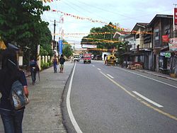
Nasipit, Agusan del Norte
| Nasipit | |||
|---|---|---|---|
| Municipality | |||

Downtown Nasipit
|
|||
|
|||
 Location within Agusan del Norte province |
|||
| Location within the Philippines | |||
| Coordinates: 8°59′N 125°20′E / 8.99°N 125.34°ECoordinates: 8°59′N 125°20′E / 8.99°N 125.34°E | |||
| Country | Philippines | ||
| Region | Caraga (Region XIII) | ||
| Province | Agusan del Norte | ||
| District | 2nd District of ADN | ||
| Municipality | August 1, 1929 | ||
| Barangays | 19 (see Barangays) | ||
| Government | |||
| • Type | Sangguniang Bayan | ||
| • Mayor | Enrico R. Corvera | ||
| • Vice Mayor | Dick Victor B. Carmona | ||
| • Congressman | Erlpe John M. Amante | ||
| Area | |||
| • Total | 144.4 km2 (55.8 sq mi) | ||
| Population (2015 census) | |||
| • Total | 41,957 | ||
| • Density | 290/km2 (750/sq mi) | ||
| • Voter (2016) | 25,926 | ||
| Time zone | PST (UTC+8) | ||
| ZIP code | 8602 | ||
| IDD : area code | +63 (0)85 | ||
| Income class | 3rd municipal income class | ||
| 160209000 | |||
| Electorate | 25,926 voters as of 2016 | ||
| Languages | |||
| Patron Saint | Saint Michael, the Archangel | ||
| Website | www |
||
Nasipit, officially the Municipality of Nasipit (Filipino: Bayan ng Nasipit), is a municipality in the province of Agusan del Norte in the Caraga (Region XIII) of the Philippines. The population was 41,957 at the 2015 census. In the 2016 electoral roll, it had 25,926 registered voters.
The Port of Nasipit is the major seaport or base port in Agusan del Norte. The Philippine Ports Authority (PPA) assigned PMO Nasipit as an International Base port.
The recorded history of Nasipit can be traced back to as early as 1880s when it was declared as a pueblo by the Spanish colonizers. According to townsfolk, its name may have been derived from an incident where a native, immediately after being bitten by a crab, was asked the name of the place by an immigrant. Misunderstanding the question, the native answered na-si-pit meaning "bitten by a crab". Since then, the town became known as Nasipit.
Nasipit was officially separated from the municipality of Butuan on August 1, 1929. It became a municipality by virtue of Executive Order No. 181 issued by Acting Governor General of the Philippines Eugene Allen Gilmore. A proposal to change its name to Aurora was initiated by former Governor Teofisto Guingona Sr., but due to the strong opposition from townsfolk, the name Nasipit was retained.
In 1949, the barrios of Carmen, Tagcatong, Cahayagan and San Agustin were separated from Nasipit and constituted into the new town of Carmen by virtue of Republic Act No. 380 which was approved on June 15, 1949.
Nasipit is located at 8°59′N 125°20′E / 8.99°N 125.34°E.
...
Wikipedia


