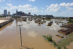
Nashville flood

Nashville, Tennessee, suffered extensive flooding, especially in areas close to the Cumberland River, Mill Creek, and Harpeth River.
|
|
| Date | May 1 – May 7, 2010 |
|---|---|
| Location | Tennessee, south central Kentucky, northern Mississippi |
| Deaths | 31 dead in TN, KY and MS |
| Property damage | $2.3 billion |
The May 2010 Tennessee floods were 1000-yearfloods in Middle Tennessee, West Tennessee, south-central and western Kentucky and northern Mississippi areas of the United States of America as the result of torrential rains on May 1 and 2, 2010. Floods from these rains affected the area for several days afterwards, resulting in a number of deaths and widespread property damage.
Two-day rain totals in some areas were greater than 19 inches (480 mm). The Cumberland River crested at 51.86 feet (15.81 m) in Nashville, a level not seen since 1937, which was before the U.S. Army Corps of Engineers flood control measures were in place. All-time record crests were observed on the Cumberland River at Clarksville, the Duck River at Centerville and Hurricane Mills, the Buffalo River at Lobelville, the Harpeth River at Kingston Springs and Bellevue, and the Red River at Port Royal.
According to the Memphis Office of the National Weather Service:
A significant weather system brought very heavy rain and severe thunderstorms from Saturday, May 1 through Sunday morning, May 2. A stalled frontal boundary coupled with very moist air streaming northward from the Gulf set the stage for repeated rounds of heavy rainfall. Many locations along the I-40 corridor across western and middle Tennessee reported in excess of 10 to 15 inches, with some locations receiving up to 20 inches according to Doppler radar estimates.
...
Wikipedia
