Narooma
|
Narooma New South Wales |
|
|---|---|

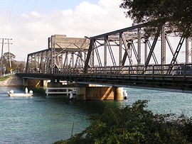
Bridge at Narooma on the Princes Highway
|
|
| Coordinates | 36°12′S 150°08′E / 36.200°S 150.133°ECoordinates: 36°12′S 150°08′E / 36.200°S 150.133°E |
| Population | 2,409 (2016 census) |
| Established | 1881 |
| Postcode(s) | 2546 |
| Location |
|
| LGA(s) | Eurobodalla Shire |
| County | Dampier |
| State electorate(s) | Bega |
| Federal Division(s) | Eden-Monaro |
Narooma is a town in the Australian state of New South Wales on the far south coast. The town is on the Princes Highway and the name Narooma is said to be derived from the Aboriginal word meaning ‘clear blue waters’. At the 2016 census, Narooma had a population of 2,605 people.
Montague Island, a National Parks and Wildlife Reserve, is eight kilometres offshore from Narooma. It is popularly thought that Lieutenant James Cook named the island as he sailed northwards up the coast of New South Wales but this is incorrect. He did name Mount Dromedary, which is located inland from Narooma, but his ship HMS Endeavour was on an easterly tack at the time, which took it far to the east of the island. From this point the island appeared to be a cape which projected from the coastline and this he named Cape Dromedary as it was below the mountain. Later, one of the ships of the Second Fleet in 1790 reported it as an island and the name "Montagu" (after George Montagu Dunk, the Earl of Halifax) was given to the Island though it is not clear by whom. Bass and Flinders later confirmed it as an island in their voyages of discovery in the late 1790s. ("The Lure of Montague" -Laurelle Pacey)
The heritage town of Central Tilba is nearby to the south.
There had been an earlier settlement nearby at Punkalla, which was a port for Bodalla and Nerrigundah; a ruined jetty and timber mill can still be seen there. Gold was discovered nearby at Central Tilba in 1880 and a post office was opened at Corunna, but called Noorooma until 1882. There is still a street bearing this spelling in the town today.
A township was surveyed at Narooma in 1883 and it was declared a port in 1884. Its school opened in 1886 and its post office in 1889. Transport to Narooma was first from the sea. From 1894 a hand-worked punt crossed Wagonga Inlet linking Narooma with Moruya. A daily mail coach ran through the town between Bega and Moruya.
...
Wikipedia

