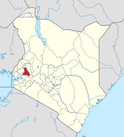
Nandi County
| Nandi County | |
|---|---|
| County | |
 Location in Kenya |
|
| Coordinates: 0°10′00″N 35°09′00″E / 0.166667°N 35.15°ECoordinates: 0°10′00″N 35°09′00″E / 0.166667°N 35.15°E | |
| Country |
|
| Formed | March 4th 2013 |
| Capital and largest town | Kapsabet |
| Government | |
| • Governor | Dr. Cleophas Lagat |
| Area | |
| • Total | 2,884.5 km2 (1,113.7 sq mi) |
| Population (2009) | |
| • Total | 752,965 |
| Time zone | EAT (UTC+3) |
| Website | nandi |
Nandi County is in North Rift of Kenya, occupying an area of 2,884.4 Km2. The County is bordered by Kakamega County to the west, Uasin Gishu County to the North East, Kericho County to the South East corner, Kisumu County to the South and Vihiga County to the South West. Geographically, the unique jug-shaped structure of Nandi County is bound by the Equator to the south and extends northwards to latitude 0034’N. The Western boundary extends to Longitude 34045’E, while the Eastern boundary reaches Longitude 35025’E.
Nandi County, earlier a part of Rift Valley Province, is a county based in Kenya. Its capital, Kapsabet, is the largest town in the county. Other towns in the county are Mosoriot and Nandi Hills. According to a 2009 census, the county has a population of 752,965
The county's major area is covered by the Nandi Hills. Although there are number of tribal communities in Nandi, the majority of the people belong to the native tribe called Nandi.
Historically, Nandi like other Kalenjin areas was divided into districts known as emotinwek (sing. emet). There were seven emotinwek in Nandi which were; Wareñg in the north, Masop in the East, Soiin (also known as Pelkut) in the south, Aldai and Chesume in the west and Em'gwen in the center.
The districts were further divided into divisions known as pororōsiek (sing. pororiet) which were made up of several villages known as koret
Following the 11-year Nandi Resistance, the traditional system of governance came to an end in 1905 with the killing of Koitalel Arap Samoei at Ketbarak in Nandi Hills. This was followed by the subsequent absorption of Nandi into the East African Protectorate in 1905 and later into the Kenya Colony in 1920.
The county (2,884.5 km2 or 1,113.7 sq mi) is further sub-divided into 30 wards namely:
Nandi County occupies 2,884.4 km2 of land characterized by hilly topography that includes an outcrop of basement systems rocks. The dissected scarp at the Southern border of the Sub-County is another manifestation of rock exposure.
The physiographic outlook of Nandi County is composed of five units with typical topography namely: the rolling hills to the West of the County, the Kapsabet plateau (part of Uasin Gishu plateau), the wooded highlands and foothills of Tinderet Volcanic mass in the South East, the Kingwal swamp in the centre (Baraton-Chepterit) and the dissected Nyando Escarpment at the Southern border (Nandi South Sub-County).
...
Wikipedia
