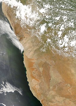
Namibe desert
| Namib Desert | |
| Desert | |
|
An image of the Namib Desert by the MODIS instrument
|
|
| Countries | Namibia, South Africa, Angola |
|---|---|
| Landmarks | Namib-Naukluft National Park, Naukluft Mountains, Skeleton Coast, Spitzkoppe, Sossusvlei, Deadvlei, Sperrgebiet |
| Rivers | Swakop River, Kuiseb River, Cunene River, Orange River, Olifants River, Tsauchab |
| Highest point | Brandberg Mountain 2,606 m (8,550 ft) |
| - location | Erongo, Namibia |
| - coordinates | 21°07′S 14°33′E / 21.117°S 14.550°E |
| Lowest point | Atlantic Ocean 0 m (0 ft) |
| Length | 2,000 km (1,243 mi), N/S |
| Width | 200 km (124 mi), E/W |
| Area | 81,000 km2 (31,274 sq mi) |
| Biome | Desert |
|
Approximate boundaries of the Namib Desert
|
|
| UNESCO World Heritage Site | |
| Criteria | (vii), (viii), (ix), (x) |
| Reference | 1430 |
| Inscription | 2013 (37th Session) |
|
[]
|
|
The Namib is a coastal desert in southern Africa. The name Namib is of Nama origin and means "vast place". According to the broadest definition, the Namib stretches for more than 2,000 kilometres (1,200 mi) along the Atlantic coasts of Angola, Namibia, and South Africa, extending southward from the Carunjamba River in Angola, through Namibia and to the Olifants River in Western Cape, South Africa. The Namib's northernmost portion, which extends 450 kilometres (280 mi) from the Angola-Namibia border, is known as Moçâmedes Desert, while its southern portion approaches the neighboring Kalahari Desert. From the Atlantic coast eastward, the Namib gradually ascends in elevation, reaching up to 200 kilometres (120 mi) inland to the foot of the Great Escarpment. Annual precipitation ranges from 2 millimetres (0.079 in) in the most arid regions to 200 millimetres (7.9 in) at the escarpment, making the Namib the only true desert in southern Africa. Having endured arid or semi-arid conditions for roughly 55–80 million years, the Namib may be the oldest desert in the world and contains some of the world's driest regions.
The desert geology consists of sand seas near the coast, while gravel plains and scattered mountain outcrops occur further inland. The sand dunes, some of which are 300 metres (980 ft) high and span 32 kilometres (20 mi) long, are the second largest in the world after the Badain Jaran Desert dunes in China. Temperatures along the coast are stable and generally range between 9–20 °C (48–68 °F) annually, while temperatures further inland are variable—summer daytime temperatures can exceed 45 °C (113 °F) while nights can be freezing.Fogs that originate offshore from the collision of the cold Benguela Current and warm air from the Hadley Cell create a fog belt that frequently envelops parts of the desert. Coastal regions can experience more than 180 days of thick fog a year. While this has proved a major hazard to ships—more than a thousand wrecks litter the Skeleton Coast—it is a vital source of moisture for desert life.
...
Wikipedia


