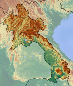
Nam Ngum Dam
| Nam Ngum Dam | |
|---|---|
|
Location of Nam Ngum Dam in Laos
|
|
| Location | Vientiane Capital, Laos |
| Coordinates | 18°31′51″N 102°32′51″E / 18.53083°N 102.54750°ECoordinates: 18°31′51″N 102°32′51″E / 18.53083°N 102.54750°E |
| Construction began | 1968 |
| Opening date | 1971 |
| Construction cost | US$97 million (over three phases) |
| Owner(s) | EDL |
| Dam and spillways | |
| Type of dam | Gravity dam |
| Impounds | Nam Ngum River |
| Height | 70 m (230 ft) |
| Length | 468 m (1,535 ft) |
| Spillway type | Radial |
| Reservoir | |
| Creates | Ang Nam Ngum |
| Total capacity | 4.7 km3 (3,800,000 acre·ft) |
| Catchment area | 8,460 km2 (3,266 sq mi) |
| Surface area | 370 km2 (140 sq mi) |
| Power station | |
| Operator(s) | EDL-GEN |
| Commission date | 1971 |
| Hydraulic head | 45.5 m (149 ft) |
| Turbines | 2 x 17.5 MW Francis 3 x 40 MW Francis |
| Installed capacity | 155 MW |
| Annual generation | 865 GW |
The Nam Ngum Dam is a hydroelectric dam on the Nam Ngum river, a major tributary of the Mekong in Laos. It was the first hydropower dam built in Lao PDR. It was constructed in three stages, beginning in with stage I in 1968 and ending with the completion of stage III in 1984. The Mekong Commission first implemented the dam project as part of the national development plan. The project was mainly focused on harnessing Lao PDR’s hydropower potential, but it has also striven to achieve flood protection, implement lift irrigation, facilitate lake fishery, and develop Lao PDR’s tourism industry. The Nam Ngum Dam has a capacity of 155MW and generates most of Laos' electricity, including all the power used in the capital, Vientiane. Additionally 70% to 80% of electricity created by the dam is exported to Thailand. The revenue from this exporting accounts for about a quarter of Laos' foreign exchange earnings. The gross power revenues of the dam are approximately US$36 million annually. However, recent studies have insinuated that the dam has adversely affected lake fishery and the wider Nam Ngum river ecosystem. Responsibility for operation of the project rests with the national power utility Electricité du Laos, a state enterprise under the Ministry of Industry and Handicraft.
Today Lao PDR’s hydropower potential is widely recognized as one of the countries main resources, since it enjoys a strategic location between the booming economies of China, Vietnam, and Thailand and rivers that contribute 35% of Mekong flows. Lao PDR has an estimated potential of some 18,000 MW from over 60 project sites on the tributaries of the Mekong River, of which less than 3 per cent has been developed.
The Nam Ngum River originates in Phou Kout in the northeastern part of the Tran Ninh Plateau, through which the river flows southwestward, and discharges into the Mekong River 55 kilometers east of Mekong city. Covering 7% of the country’s land area, the Nam Ngum Basin is home to roughly 500,000 people, representing approximately 9% of Lao PDR’s total population. The total length of the river is 420 kilometers. The Nam Ngum project is situated 60 kilometers north of Vientiane on the Nam Ngum tributary of the Mekong, within the Vientiane Capital Province. The Nam Ngum catchment covers 8,460 km2 (3,266 sq mi), and is on track to becoming one of the most heavily dammed catchments in Laos, with six additional dams at various stages of planning and construction, and two water diversions.
...
Wikipedia

