Nam Et
| Nam Et / Phou Louey National Biodiversity Conservation Area | |
| Protected area | |
| Name origin: Nam Et River and Phou Louey (“Forever Mountain”) | |
| Country | Laos |
|---|---|
| Province | Houaphan, Luang Prabang, Xieng Khouang |
| Elevation | 1,000 m (3,281 ft) |
| Coordinates | 20°00′N 103°18′E / 20°N 103.3°ECoordinates: 20°00′N 103°18′E / 20°N 103.3°E |
| Area | 3,000 km2 (1,158 sq mi) |
| IUCN category | VI - Managed Resource Protected Area |
|
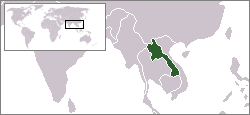
Southeast Asia, Laos (green)
|
|
| Website: Lao People’s Democratic Republic, National Report on Protected Areas and Development | |
Nam Et-Phou Louey National Biodiversity Conservation Area (NBCA) is a protected area in northern Laos, covering 5,959 km2 in three provinces — Houaphan, Luang Prabang and Xieng Khouang. The park includes a 3,000 km2 core area where human access and wildlife harvest is prohibited and a 2,950 km2 buffer area where pre-existing villages are allocated land for subsistence living.
The park consists mainly of mountains and hills, with altitude ranging between 336 and 2257 metres above sea level. The area is the source of many rivers. It is named after the Nam Et River and Phou Louey Mountain (“Forever Mountain”). The area has a high level of biodiversity and endangered species including tiger, leopard, clouded leopard, Asian golden cat, marbled cat, civet, gaur, Sambar deer, white-cheeked gibbon, sun bear, black bear, Asian elephant, dhole, hornbill and three species of otter.
Villagers living in the Nam Et-Phou Louey National Park include Tai Dam, Tai Daeng, Tai Kao, Tai Puan, Tai Lue, Tai Yuan, Khmu, Hmong Kao, Hmong Lai, and Yao.
Viengthong, a small town in Houaphan Province, is the location of the Nam Et-Phou Louey NPA headquarters and visitor centre, where tours into the park can be organised. The town has basic accommodation and a handful of restaurants serving Lao food. There are many biking and walking trails, as well as hot springs.
...
Wikipedia

