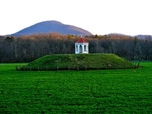
Nacoochee Mound

The Nacoochee Mound
|
|
| Location |
Helen, Georgia, White County, Georgia, |
|---|---|
| Region | White County, Georgia |
| Coordinates | 34°41′01″N 83°42′32″W / 34.68351°N 83.709°W |
| History | |
| Founded | 100 BCE |
| Abandoned | 1600 CE |
| Periods | Early Middle Woodland, Lamar Phase |
| Cultures | South Appalachian Mississippian culture |
| Site notes | |
| Excavation dates | 1915, 2004 |
| Archaeologists | Frederick Webb Hodge, George H. Pepper |
| Architecture | |
| Architectural styles | platform mound |
| Architectural details |
Number of temples: 1 |
|
Sautee Valley Historic District
|
|
| NRHP Reference # | 86002742 |
| Added to NRHP | August 20, 1986 |
Coordinates: 34°41′01″N 83°42′32″W / 34.6835°N 83.709°W
Number of temples: 1
The Nacoochee Mound (Smithsonian trinomial 9WH3) is an archaeological site on the banks of the Chattahoochee River in White County, in the northeast part of the U.S. state of Georgia, at the junction of Georgia Georgia State Route 17 and Georgia State Route 75. First occupied as early as 100-500 CE, the site was later developed and occupied more intensively by peoples of the South Appalachian Mississippian culture (a regional variation of the Mississippian culture) from 1350 to 1600 CE. One of their characteristic platform mounds is located at the site. A professional archeological excavation revealed a total of 75 human burials, with artifacts that support dating of the site.
The mound was excavated, but a reconstruction was built. The 19th-century gazebo was added by a European-American owner of the land.
Unlike other Mississippian sites, this does not appear to have been occupied by the later Cherokee peoples. The site is part of the Sautee Valley Historic District; it was added to the National Register of Historical Places on August 20, 1986 as reference number 86002742.
...
Wikipedia

