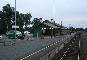
Murchison East railway station
|
Murchison East
|
|||||||||||
|---|---|---|---|---|---|---|---|---|---|---|---|

Northbound view in July 2007. The original station building has since been demolished due to a fire.
|
|||||||||||
| Location | Cassidys Road, Murchison | ||||||||||
| Coordinates | 36°36′47″S 145°14′26″E / 36.6131°S 145.2405°ECoordinates: 36°36′47″S 145°14′26″E / 36.6131°S 145.2405°E | ||||||||||
| Owned by | VicTrack | ||||||||||
| Operated by | V/Line | ||||||||||
| Line(s) | |||||||||||
| Distance | 147.25 kilometres from Southern Cross | ||||||||||
| Platforms | 1 | ||||||||||
| Tracks | 3 | ||||||||||
| Construction | |||||||||||
| Structure type | Ground | ||||||||||
| Other information | |||||||||||
| Status | Unstaffed | ||||||||||
| Station code | MST | ||||||||||
| Fare zone | Myki zone 11 | ||||||||||
| Website | Public Transport Victoria | ||||||||||
| History | |||||||||||
| Opened | 13 January 1880 | ||||||||||
| Services | |||||||||||
|
|||||||||||
Murchison East railway station is located on the in Victoria, Australia. It serves the town of Murchison, opening on 13 January 1880.
'The station became a junction in September 1890 when the line to Rushworth opened, this line later being extended to Colbinabbin and Girgarre. The Rushworth line closed in 1987, and branched off at the southern end of the station.
The main timber station building has been fenced off, replaced by a new passenger shelter alongside. The station has the longest passing loop on the line, 870 metres in length, however in 2013 the loop was booked out of service due to poor track condition. A number of other sidings that serve a grain silo complex are opposite the platform. On 4 June 2014, the main building of the station was destroyed by a fire.
Flashing lights were provided at the nearby Goulburn Valley Highway level crossing in 1974. Boom barriers have since been added to the level crossing.
Closed station Wahring was located between Murchison East and Nagambie, while Arcadia and Toolamba railway stations were located between Murchison East and Mooroopna.
Murchison East has one platform. It is serviced by V/Line services.
Platform 1:
...
Wikipedia
