Municipal Council of Roxby Downs
|
Municipal Council of Roxby Downs South Australia |
|||||||||||||||
|---|---|---|---|---|---|---|---|---|---|---|---|---|---|---|---|

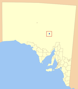
Location of the Municipal Council of Roxby Downs in blue
|
|||||||||||||||
| Coordinates | 30°30′28″S 136°54′57″E / 30.5079°S 136.9157°ECoordinates: 30°30′28″S 136°54′57″E / 30.5079°S 136.9157°E | ||||||||||||||
| Population | 4,484 (2009) | ||||||||||||||
| • Density | 39.0/km2 (101/sq mi) | ||||||||||||||
| Established | 1982 | ||||||||||||||
| Area | 110 km2 (42.5 sq mi) | ||||||||||||||
| Council seat | Roxby Downs | ||||||||||||||
| Region | Far North | ||||||||||||||
| State electorate(s) | Giles | ||||||||||||||
| Federal Division(s) | Grey | ||||||||||||||
 |
|||||||||||||||
| Website | Municipal Council of Roxby Downs | ||||||||||||||
|
|||||||||||||||
The Municipal Council of Roxby Downs is the local government area covering the town of Roxby Downs and the Olympic Dam mine in South Australia. It has an area of 110 km², and an estimated population of 4,484. The municipality was established in 1982. It is the only local government area in South Australia to not have an elected council.
It covers most of the locality of Roxby Downs, except a portion to the east of the town, while also including a section of the adjacent locality of Olympic Dam.
...
Wikipedia
