Mulwala
|
Mulwala New South Wales |
|
|---|---|

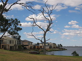
New residential development on the shore of Lake Mulwala.
|
|
| Coordinates | 35°58′55″S 146°00′04″E / 35.98194°S 146.00111°ECoordinates: 35°58′55″S 146°00′04″E / 35.98194°S 146.00111°E |
| Population | 1,986 (2006 census) |
| Established | 1858 |
| Postcode(s) | 2647 |
| Location |
|
| LGA(s) | Federation Council |
| County | Denison |
| State electorate(s) | Albury |
| Federal Division(s) | Farrer |
Mulwala /mʌlˈwɑːlə/ is a town in the Federation Council local government area in the Riverina district of New South Wales, Australia. The town is situated on Lake Mulwala, an artificial lake formed by the damming of the Murray River. At the 2006 census, Mulwala had a population of 1,986 people. The town's name is derived from an aboriginal word for 'rain'.
Across the border in Victoria is Mulwala's twin town of Yarrawonga.
Mulwala is a popular destination for water sports and fishing, especially for tourists from nearby Melbourne, 300 kilometres (190 mi) to the south. Other popular attractions include three major licensed clubs.
The local Australian rules football club, Mulwala Football Club competes in the Murray Football League.
In 1847 James McRae arrived in the district to take charge of "Mulwala" and "Boroge" stations on behalf of the squatter Linbourne. McRae built a punt and a public house at the locality. He obtained a licence for his Travellers' Rest Hotel in 1853.
In 1858 Surveyor Adams marked out a township at the site. In 1866 a new hotel was opened at Mulwala and a school established at the township. Mulwala Post Office opened in 1864 for about six weeks, closed due to a large fire, and was reopened on 1 June 1866. The pioneer, James McRae, died in 1866.
...
Wikipedia

