Mueang Suphan Buri District
|
Mueang Suphanburi เมืองสุพรรณบุรี |
|
|---|---|
| Amphoe | |
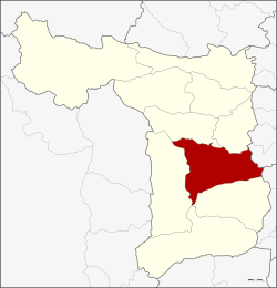
 Amphoe location in Suphanburi Province |
|
| Coordinates: 14°29′4″N 100°7′25″E / 14.48444°N 100.12361°ECoordinates: 14°29′4″N 100°7′25″E / 14.48444°N 100.12361°E | |
| Country |
|
| Province | Suphanburi |
| Area | |
| • Total | 540.9 km2 (208.8 sq mi) |
| Population (2013) | |
| • Total | 166,716 |
| • Density | 292.3/km2 (757/sq mi) |
| Time zone | THA (UTC+7) |
| Postal code | 72000 |
| Geocode | 7201 |
Mueang Suphan Buri (Thai: เมืองสุพรรณบุรี; IPA: [mɯ̄aŋ sù.pʰān būrīː]) is the capital district (Amphoe Mueang) of Suphan Buri Province, central Thailand.
Suphan Buri is an old city. In the era of Ankorian king Jayavarman VII, inscription called Prasat Phra Khan (จารึกปราสาทพระขรรค์) was made and which mentions the name of Suvarnapura. Later Suphan Buri become important city of Ayutthaya kingdom. According to Chinese Annals called "Da Ming Shi Lu" (『大明実録』), Nakharinthathirat (Intharatcha or Nakhon In), before ascending the throne of Ayutthaya, was a ruler of Suphan Buri and tribute to Chinese Emperor as a King of Supan Buri (Su Men Bang Wang or 蘇門邦王). Later in the 16th century, Suphan Buri become battle field of King Naresuan and Burmese crown prince.
This area was the center of Mueang Suphan Buri. When the government created a district, it was called Wihan Daeng. Later the district name was changed to be Tha Phi Liang. In 1939 the district name was changed to be Mueang Suphan Buri to correspong with the province name.
Neighboring districts are (from the south clockwise) Bang Pla Ma, U Thong, Don Chedi, Si Prachan of Suphan Buri province, Wiset Chai Chan of Ang Thong province and Phak Hai of Ayutthaya Province.
...
Wikipedia
