Mueang Chon Buri District
|
Mueang Chonburi เมืองชลบุรี |
|
|---|---|
| Amphoe | |

The Khao Khiao Massif rising east of Chonburi
|
|
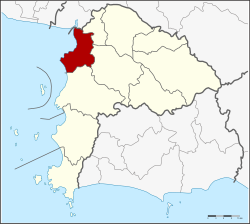
 Amphoe location in Chonburi Province |
|
| Coordinates: 13°21′43″N 100°58′45″E / 13.36194°N 100.97917°ECoordinates: 13°21′43″N 100°58′45″E / 13.36194°N 100.97917°E | |
| Country | Thailand |
| Province | Chonburi |
| Seat | Bang Pla Soi |
| Area | |
| • Total | 228.8 km2 (88.3 sq mi) |
| Population (2015) | |
| • Total | 322,057 |
| • Density | 1,407.59/km2 (3,645.6/sq mi) |
| Time zone | ICT (UTC+7) |
| Postal code | 20000 |
| Geocode | 2001 |
Mueang Chonburi (Thai: เมืองชลบุรี, rtgs: Mueang Chon Buri, pronounced [mɯ̄aŋ t͡ɕʰōn bū.rīː]) is the capital district (amphoe mueang) of Chonburi Province, eastern Thailand.
Neighbouring districts are (from the north clockwise) Bang Pakong of Chachoengsao Province, Phan Thong, Ban Bueng and Si Racha. To the west is the Bay of Bangkok.
The district is divided into 18 sub-districts (tambon), which are further subdivided into 107 villages (muban). There are three towns (thesaban mueang) - Chonburi, Saen Suk, and Ban Suan. More municipal areas are three townships (thesaban tambon): Khlong Tamru, Bang Sai, and Ang Sila. There are further 10 tambon administrative organisations (TAO).
...
Wikipedia
