Muñoz, Nueva Ecija
| Muñoz | ||
|---|---|---|
| Component City | ||
| Science City of Muñoz | ||

City Hall
|
||
|
||
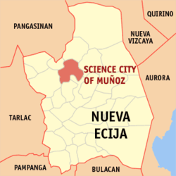
 Map of Nueva Ecija showing the location of Muñoz |
||
| Location within the Philippines | ||
| Coordinates: 15°43′N 120°54′E / 15.717°N 120.900°ECoordinates: 15°43′N 120°54′E / 15.717°N 120.900°E | ||
| Country | Philippines | |
| Region | Central Luzon (Region III) | |
| Province | Nueva Ecija | |
| District | 2nd District | |
| Founded | 1913 | |
| Cityhood | December 9, 2000 | |
| Barangays | 37 | |
| Government | ||
| • Mayor | Nestor Lazaro Alvarez | |
| Area | ||
| • Total | 163.05 km2 (62.95 sq mi) | |
| Population (2010) | ||
| • Total | 75,462 | |
| • Density | 460/km2 (1,200/sq mi) | |
| Time zone | PHT (UTC+8) | |
| ZIP Code | 3119, 3120 | |
| IDD : area code | +63 (0)44 | |
| Income class | 4th class city | |
| Website | www |
|
Muñoz , officially the Science City of Muñoz, is a city in the province of Nueva Ecija, Central Luzon, Philippines, situated 151 kilometres (94 mi) north of the capital Manila. Due to its rich topography and tropical climate, it is now home to agricultural research and technology centers, committed to the production of information and technological breakthroughs to promote rural development, productivity and food security.
From its lowly origins as “Sitio Papaya”, it was renamed as Muñoz in 1886 in honor of Spanish Governor Don Francisco Muñoz. It was in 1913, under Executive Order No. 72, when Muñoz was declared as a new and independent municipality.
Muñoz is politically subdivided into 37 barangays:
In 1886, Papaya was changed into 'Muñoz' to honor Don Francisco Muñoz, the province’s alcalde mayor, and the community’s first appointed gobernadorcillo. Muñoz was annexed as a barrio of San Juan de Guimba municipality. Settlers trickled in from Bulacan and the Ilocos Region. In 1911, Factoria (now San Isidro town), the provincial capital, was totally flooded. Muñoz was then considered a possible new capital of the province.
At about the same time, the people of Barrios Muñoz and San Antonio, also in San Juan de Guimba town, and Palusapis in Sto. Domingo municipality, together with Sitios Kabisukulan, Rang-ayan, Mataas na Lupa, Siniguelas, Purok Agrikultura, and Pulong Maragul in Talavera town, were organizing themselves to be separated from their three respective municipalities to become a new independent municipality. They were prepared to construct a municipal hall and a school building for the emerging town.
On the recommendation of the Provincial Board of Nueva Ecija, then headed by Governor Isauro Gabaldon, and with approval of then Acting Governor General Newton Gilbert, the organized barrios and sitios were granted independence as a regular municipality on January 10, 1913 under the name of Muñoz. The seat of the fledgling municipal government was positioned in erstwhile Barrio Muñoz. The municipality of Muñoz was born and steadily grew to become an agricultural Science City in the making.
A municipal hall, a church, and a small public market were erected in Lumang Bayan (now Poblacion North). A road linking the young Muñoz town with the national highway from Barangay Bacal, Talavera was constructed. In World War II, Muñoz was the last stronghold of the Japanese Imperial Army; the Allied liberation in Muñoz by the joint United States and Philippine Commonwealth forces offensive razed the town to the ground in a matter of days.
...
Wikipedia


